

Understand Site Topography and Its Role in Sustainable Design for Eco-Friendly Solutions
Discover how understanding site topography transforms sustainable design by optimizing energy use, water management, and ecosystem preservation. Learn to harness land contours with tools like GIS and LiDAR to create environmentally conscious spaces that align with nature, reduce costs, and enhance resilience while tackling challenges like irregular terrain and erosion control.

Table of Contents Show
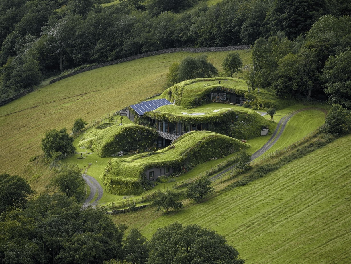
When we think about sustainable design, we often focus on energy efficiency, materials, or water conservation. But have we ever considered how the land itself shapes our approach? Site topography—the natural contours and features of a landscape—plays a crucial role in creating environmentally responsible designs that harmonize with their surroundings.
By understanding a site’s topography, we can work with the land rather than against it. From managing water flow to optimizing natural light and ventilation, topography offers insights that help us reduce environmental impact while enhancing functionality. It’s not just about building on the land; it’s about building with it.
Incorporating topography into sustainable design isn’t just smart—it’s essential. By respecting the natural terrain, we create spaces that are not only efficient but also resilient and deeply connected to their environment. Let’s explore how topography shapes the foundation of truly sustainable design.
What Is Site Topography?
Site topography refers to the physical characteristics and arrangement of a land surface, including its shape, elevation, and natural features. It’s a critical element in sustainable design, ensuring developments align with the land’s natural attributes.

Defining Site Topography
Site topography encompasses contours, slopes, and elevations that define the terrain. These features influence water drainage, soil stability, and vegetation patterns. By analyzing topography, we gain insights into the land’s structure and potential for environmental design solutions.
Key Components of Site Topography
- Contour Lines represent elevation changes, showing the land’s slope direction and steepness. For example, closely spaced lines indicate steep terrain, while widely spaced lines suggest gentle slopes.
- Slope Gradients measure the angle of the land, impacting accessibility, water runoff, and site planning decisions.
- Elevation Levels describe the height of landforms, affecting microclimate and structural design needs.
- Natural Features include elements like rocks, streams, and vegetation, shaping how the site interacts with natural systems.
- Drainage Patterns guide water flow across a landscape, mitigating erosion risks and managing stormwater in design projects.
The Role of Site Topography in Sustainable Design
Site topography shapes how we design sustainable solutions that align with the land’s natural features. By leveraging topography, we can integrate energy efficiency, water management, and ecosystem preservation into our designs.

Enhancing Energy Efficiency
Site topography helps us optimize building orientation and design for energy conservation. Structures placed on south-facing slopes can maximize solar exposure, while shading from high elevations helps reduce heat gain in warmer climates. Natural ventilation is enhanced by positioning buildings to leverage prevailing wind patterns influenced by terrain.
Supporting Stormwater Management
Topographical analysis allows us to channel water efficiently while preventing erosion. Gentle slopes can direct stormwater to retention areas, reducing runoff and minimizing flood risks. Existing drainage patterns help us design systems that promote groundwater recharge and reduce disruption to hydrological cycles.
Preserving Natural Ecosystems
Understanding topography minimizes disruption to local ecosystems during development. We can preserve natural landforms, such as hills and valleys, maintaining habitats for plant and animal life. Terrain features, like wetlands and vegetated slopes, support biodiversity by integrating them into design rather than altering them.
Tools To Analyze Site Topography
Analyzing site topography requires accurate tools that ensure informed sustainable design decisions. We leverage both traditional and modern technologies to map and understand land features effectively.

Traditional Surveying Methods
Traditional methods rely on direct observation and manual measurements, offering precise data for smaller-scale projects. Common tools include:
- Theodolites: Measure horizontal and vertical angles, essential for determining contour gradients.
- Levels and Rods: Provide accurate elevation data by measuring height differences across points.
- Total Stations: Combine angle measurement and electronic distance measurement (EDM) for greater accuracy.
These methods are labor-intensive but deliver high accuracy for site-specific details. We often use them when digital tools aren’t feasible.
Modern Digital Tools and Technologies
Digital tools streamline topographical analysis by providing automated and large-scale data collection. Common technologies include:
- GIS (Geographic Information System): Integrates spatial data with terrain analysis to model natural features and infrastructure seamlessly.
- LiDAR (Light Detection and Ranging): Uses laser pulses to generate detailed elevation maps for complex terrains.
- Drones: Capture aerial imagery with high-resolution cameras, enabling quick and cost-effective site mapping.
- Topographic Software: Programs like AutoCAD Civil 3D and ArcGIS process raw data into 3D models for enhanced analysis and visualization.
By integrating modern tools, we analyze sites faster, at scale, and with improved data precision, aiding sustainable design strategies.
Benefits Of Integrating Topography In Sustainable Design
Incorporating site topography into sustainable design promotes efficiency while minimizing environmental disruption. It enhances resource use, reduces costs, and sustains ecosystems.

Cost Efficiency in Construction
Topography-guided designs reduce material and labor needs by adapting structures to the land’s natural contours. For example, slope adaptation minimizes extensive excavation and grading, lowering construction energy consumption and associated costs. Natural drainage patterns, when preserved, reduce reliance on artificial water management systems like retention basins. Additionally, designing around natural slopes supports passive heating and cooling systems, cutting operational energy expenses long-term.
Long-term Environmental Benefits
Designs that integrate topography preserve natural habitats and enhance biodiversity. Maintaining existing vegetation and water runoff patterns minimizes soil erosion and reduces the environmental footprint of development. For instance, terraced construction stabilizes soils on steep slopes, preventing landslides and promoting agricultural productivity. Using the terrain for natural storm water management improves groundwater recharge and decreases local flooding risks. Through these approaches, we align our designs with sustainable climate resilience goals.
Challenges in Leveraging Site Topography
Working with site topography in sustainable design presents unique challenges that require careful planning and innovative strategies. Addressing these complexities ensures designs are both functional and environmentally responsible.

Addressing Complex Landscape Features
Understanding and utilizing irregular terrain, steep slopes, and varying elevations complicates project planning. For example, steep slopes can limit construction options, increase excavation costs, and create issues with soil erosion. Uneven terrains demand custom structuring, increasing the difficulty of aligning buildings with environmental goals. Additionally, unique natural features like rock formations, water bodies, or dense vegetation may present obstacles when integrating these elements into sustainable designs without disruption.
Proper mapping and three-dimensional modeling contribute significantly to navigation of these complexities. Leveraging GIS or drone technology helps designers analyze intricate landforms, enabling solutions such as tiered construction for slopes or incorporating waterways into stormwater management systems. These tools facilitate designs that embrace rather than fight the land’s natural characteristics.
Mitigating Human and Environmental Impacts
Balancing site modifications with minimal environmental disturbance remains challenging. Poorly managed grading and alterations during construction may disrupt soil stability, increase erosion risks, and harm local biodiversity. Meanwhile, large-scale terrain adjustments often elevate project costs and energy consumption, negatively impacting sustainability goals.
To address these, we focus on adaptive design techniques such as selective grading or retaining walls that stabilize terrains while preserving the natural ecosystem. Erosion control strategies, like vegetation buffers or permeable landscapes, reduce runoff and maintain soil health. Maintaining a balance between human needs and environmental preservation ensures both long-term viability and minimal ecological disruption.
Conclusion
Understanding site topography plays a transformative role in achieving sustainable design by aligning development with natural land features. By integrating topographical analysis into our processes, we can enhance energy efficiency, manage water resources effectively, and preserve ecosystems. Using modern tools like GIS and LiDAR alongside traditional methods enriches our ability to adapt designs to the environment, ensuring harmony between construction and nature. Addressing challenges such as irregular terrain and steep slopes requires innovative approaches and adaptive strategies that prioritize minimal environmental impact.


Best Orientation for a House: Why North Orientation Matters
North orientation shapes a home's light, warmth, and running costs, and its...

Passive Design Architecture: A Practical Guide to Low-Energy Buildings
Passive design uses a building's orientation, form, and materials to control heat,...

Passive House vs LEED Certification: Which Green Standard Should You Pursue?
Passive House focuses on strict energy performance and airtightness, while LEED scores...

The Importance of Concept in Sustainable Architecture
A sustainability diagram in architecture visually communicates how environmental, social, and economic...

Leave a comment