

Mixed-Use Development vs Single-Use Zoning: The Urban Planning Debate
Urban planning has long debated mixed-use development versus single-use zoning. This comparison covers their history, walkability, tax impact, and trade-offs, with sourced data and real examples to clarify which model suits modern cities.

Table of Contents Show
Urban planning weighs two land-use models: mixed-use development, which combines housing, retail, and offices in one area, and single-use zoning, which separates them into distinct districts. Mixed-use supports walkable neighborhoods and shorter commutes, while single-use zoning offers predictability and clear noise separation. The right choice depends on density, transit access, and community goals.
Few decisions shape a city more than how it sorts land. The debate between mixed-use development and single-use zoning sits at the center of modern urban planning, and it touches everything from housing affordability to traffic, tax revenue, and public health. Planners, developers, and residents rarely agree on which model serves a community best, partly because each one solves real problems while creating new ones.

What Is the Difference Between Mixed-Use and Single-Use Zoning?
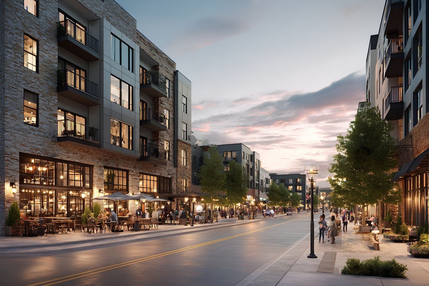
Single-use zoning assigns each parcel of land to one function: housing here, shops there, factories somewhere else. Mixed-use development does the opposite, layering residential, commercial, and sometimes light industrial uses within a single building or block. A mixed-use street might place apartments above a grocery store and a cafe, with offices on the upper floors.
The distinction is not just architectural. It defines how far people travel for daily needs, how streets feel at night, and how a tax base holds up over time. Single-use zoning, also called Euclidean zoning, has been the default in North America for nearly a century, according to Britannica. Mixed-use is the older pattern, found in nearly every city built before the automobile.
How Single-Use Zoning Shaped Modern Cities
The legal foundation arrived in 1926. In Village of Euclid v. Ambler Realty Co., the U.S. Supreme Court upheld a town’s right to separate land uses, treating zoning as a valid use of police power. The phrase “a pig in the parlor,” used to describe a factory in a residential area, captured the era’s logic. The Lincoln Institute of Land Policy notes that the ruling was a response to genuine harm, since smelters and tanneries once sat beside worker housing during the Industrial Revolution.
Separating heavy industry from homes made sense. The problem came later, when cities applied the same separation to everything. Shops were pushed away from houses, offices away from apartments, and the result was sprawl that required a car for almost every trip. The American Bar Association points out that the model state act behind most zoning codes did not even provide direction for mixing uses, so single-use districts became standard practice by default rather than by careful design.
💡 Pro Tip
When reviewing a parcel for mixed-use potential, check the parking minimums before anything else. Outdated parking ratios written for single-use sites often kill otherwise viable mixed-use projects by forcing developers to dedicate ground floors to garages instead of active street frontage.
Why Mixed-Use Development Gained Momentum
Over the past two decades, planners have pushed back against rigid separation. The appeal of mixed-use comes down to proximity. When homes, jobs, and services sit close together, residents drive less and walk more. The U.S. EPA reports that in well-designed, centrally located neighborhoods, residents drive as little as half as much as people in outlying suburbs, which lowers both household costs and emissions.
Mixed-use zoning also strengthens local economies. Foot traffic supports small businesses, and blended districts often generate higher returns for local governments through property and sales taxes while costing less per unit to service. These patterns are central to the design of mixed-use public spaces that aim to balance commerce and community life. Walkable, blended neighborhoods are now a recurring theme in sustainable urban design.
🔢 Quick Numbers
- In Arlington, Virginia, two compact, mixed-use Metrorail corridors hold 48% of the county’s assessed property value on just 11% of its land (U.S. EPA, Smart Growth and Economic Success, 2014).
- A 10-point rise in Walk Score raised commercial property values by 1 to 9% depending on type, across more than 4,200 properties (Pivo and Fisher, “The Walkability Premium in Commercial Real Estate Investments,” Real Estate Economics).
- Transportation produced 33% of U.S. carbon dioxide emissions, with 83% of that from on-road vehicles, which compact mixed-use development helps reduce (U.S. EPA Smart Growth Guide).
The shift is not only physical. Data-driven tools now help planners model how blended districts perform before a single building goes up, a trend covered in our look at AI in urban planning.

Mixed-Use vs Single-Use Zoning: A Direct Comparison
Neither model wins on every measure. The table below compares the two across the factors that matter most to planners and residents.
| Factor | Mixed-Use Development | Single-Use Zoning |
|---|---|---|
| Daily travel | Shorter trips, more walking and transit | Longer trips, car dependent |
| Street life | Active across day and evening | Quiet, often empty after hours |
| Tax revenue per acre | Higher in dense, transit-served areas | Lower, spread over more land |
| Noise and conflict | Possible friction between uses | Clear separation, fewer disputes |
| Development risk | Complex financing and approvals | Predictable, easier to permit |
| Housing supply | Adds homes near jobs and services | Limits density, can raise prices |
The trade-offs are real. Mixed-use delivers vibrancy and efficiency but demands sophisticated design and financing. Single-use zoning offers certainty and quiet but tends to spread a city thin and lock out housing. Reading these patterns on paper is one reason planners rely on zoning diagrams to map how uses sit beside one another before approval.
🏗️ Real-World Example
Santana Row (San Jose, 2002): Built on the site of an aging shopping mall, this district mixes housing, retail, restaurants, and offices along walkable streets. It replaced a single-use commercial parcel with a block that stays active well beyond store hours, a model the EPA cites for generating fewer vehicle trips than conventional development.
Where Each Model Still Makes Sense
The debate is rarely all or nothing. Single-use zoning still has a place. Heavy industry, airports, and certain manufacturing genuinely need separation from homes for safety and health. The original concern that drove the 1926 ruling has not disappeared.
Mixed-use, meanwhile, performs best where density and transit already exist or are planned. Dropping a mixed-use block into a car-dependent suburb with no bus service often disappoints, since the proximity benefits depend on people being able to reach things on foot. Successful conversions usually pair zoning reform with investment in sidewalks, transit, and the kind of pedestrian infrastructure explored in our guide to urban walkway design. The growing middle ground is form-based code, which regulates building shape and street relationship rather than strictly separating uses.
Building codes and zoning regulations vary by jurisdiction. Always consult local planning authorities before relying on any land-use approach for a specific project.
The Bigger Picture
Bottom Line: Single-use zoning solved a real problem in 1926 but became a blunt instrument that fueled sprawl and limited housing. Mixed-use development restores the proximity that older cities had, with measurable gains in walkability, tax efficiency, and emissions, though it asks more of designers and financiers. The strongest urban planning approach treats them as tools rather than ideologies, matching each to the density, transit, and goals of the place it serves.


The Instagram City: How Social Media Filters Urban Reality
From selfie walls to color-coded facades, the instagram city phenomenon is reshaping...

The Art of AI Urban Planning: Designing Livable and Sustainable Cities
I urban planning is moving from research labs into city halls, helping...

Snøhetta, MVRDV and BIG Design Istanbul’s Ion Riva Master Plan
The Ion Riva Master Plan is one of Istanbul's most significant recent...

Sustainability Landmark in Rotterdam: 5 Shortlisted Teams
Five leading architecture firms — MVRDV, Heatherwick Studio, Mecanoo, Office for Political...

Leave a comment