

Elevation Drawing in Architecture: Types, Tools & Best Practices
Elevation drawings are scaled, two-dimensional representations of a building's vertical faces used throughout the design and construction process. This guide covers the definition, types (front, side, rear, interior), essential software tools, step-by-step creation methods, and reading tips for architectural elevations.

Table of Contents Show
Elevation Drawing in Architecture: Types, Tools, and Best Practices
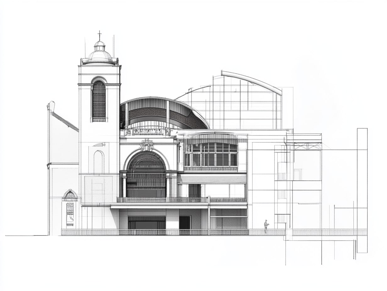
An elevation drawing in architecture is a two-dimensional, scaled representation of one vertical face of a building. Unlike perspective renderings, elevation drawings use orthographic projection to show a structure’s exterior without foreshortening or visual distortion. These drawings form one of the three core architectural drawing types alongside floor plans and section drawings, and they remain essential throughout the design and construction process.
Whether you are an architecture student learning foundational drawing skills or a homeowner trying to understand your architect’s documentation, knowing what elevation drawings are and how to read them will help you make better decisions at every project stage. This article covers the definition of elevation drawing, its importance, the main types of architectural elevations, the tools professionals use to create them, and practical tips for producing effective elevation drawings.

What Is an Elevation Drawing in Architecture?
So what is an elevation in architecture, exactly? An elevation drawing is a flat, two-dimensional view of one side of a building, drawn to scale and projected onto a vertical plane. Imagine standing directly in front of a structure and looking straight at it without any perspective distortion. That flat, head-on view is what an elevation captures on paper.
The elevation drawing definition can be broken down further: it is an orthographic projection of a building’s exterior (or interior wall) that shows heights, proportions, materials, fenestration, and architectural details. According to Francis D.K. Ching’s widely referenced textbook Architectural Graphics, an elevation is an orthographic projection of an object onto a vertical picture plane parallel to one of its principal faces.
Elevation meaning in architecture extends beyond a simple drawing type. The term “elevation” can also refer to the height of a point above a fixed reference datum, but in the context of architectural drawings, it specifically means the visual representation of a vertical building surface.
Importance of Architectural Elevation Drawings
Architectural elevation drawings play a vital role in the building design process. They provide essential visual details necessary for successful construction.

Visualization of Design Intent
Elevation drawings enable clear visualization of the architectural design intent. You can observe exact placements of windows, doors, and finishes, gaining a full overview of how the structure interacts with its environment. With detailed elevations, every aspect (rooflines, materials, textures) aligns with the original vision. This clarity reduces misunderstandings during construction, allowing the project to progress smoothly. Unlike 3D renderings that emphasize atmosphere and mood, elevations prioritize dimensional accuracy and material specification, making them indispensable for builders who need precise vertical measurements.
Communication Tool for Stakeholders
Elevation drawings serve as an effective communication tool for all project stakeholders. They bridge the gap between architects, builders, and clients, facilitating a shared understanding of the project. These drawings convey key design elements, enhancing collaboration between team members. Accurate elevations also support zoning approvals and building permits, ensuring compliance with local regulations. According to the American Institute of Architects (AIA), elevation drawings are a mandatory component of most permit submission packages in the United States, and similar requirements exist in countries governed by bodies like RIBA in the United Kingdom.
Regulatory Compliance and Permits
Many municipalities require detailed building elevation drawings as part of the planning and permitting process. Zoning boards evaluate elevations to verify that a proposed building meets height restrictions, setback requirements, and aesthetic guidelines for the neighborhood. Without clearly drawn architectural elevations, approval delays are common. Including accurate material callouts, finished floor levels, and boundary line references on your elevations can speed up the review process considerably.
Types of Architectural Elevation Drawings
Understanding the various types of architectural elevation drawings is essential for grasping their specific functions in the design process. Each type provides unique insights into a building’s exterior from different perspectives. Most residential projects require a minimum of four elevations, while commercial buildings with complex footprints may need significantly more.

Front Elevation
Front elevation drawings depict the main facade of a building. These drawings showcase the design features, including windows, doors, and architectural details. Front elevations present the structure as seen from the primary approach, helping you visualize the entrance and overall aesthetic. They often include notes on materials and colors, supporting decisions on finishes and landscaping. In planning submissions, the front elevation receives the most scrutiny because it defines the building’s street presence and public character.
Side Elevation
Side elevation drawings illustrate the building’s lateral views, either left or right. They provide additional context to the design by highlighting rooflines, wall heights, and any protruding elements such as balconies or chimneys. Side elevations enable you to assess how the building relates to adjoining structures and the surrounding environment, ensuring all elements harmonize with the proposed design. These views are particularly important for properties on narrow lots where setback compliance depends on precise sidewall measurements.
Rear Elevation
Rear elevation drawings capture the view of a building from the back. These representations often reveal secondary entrances, service areas, and structural components not visible from the front. Rear elevations also play a crucial role in planning for outdoor spaces, such as patios or gardens, ensuring that design continuity extends to the back of the building.
Interior Elevation
While exterior elevations are the most commonly discussed type, interior elevations are equally important for construction documentation. An interior elevation shows a straight-on view of an individual wall within a room. These drawings are especially useful for kitchens, bathrooms, and custom millwork, where the precise placement of cabinetry, shelving, fixtures, and outlets must be documented. Interior elevations complement floor plans by revealing vertical details that a horizontal view cannot capture.
Elevation Drawing Naming Conventions
Architects use two common naming systems for elevation drawings. The first uses compass directions (North, South, East, West) based on the direction each face of the building points toward. The second system labels elevations by their relationship to the street or site (Front, Left Side, Rear, Right Side). On plan drawings, small elevation tag symbols with arrows indicate which direction each elevation view faces.
Comparison of Elevation Drawing Types
The following table summarizes the key characteristics of each type of elevation drawing in architecture:
| Elevation Type | Primary Purpose | Key Details Shown | Common Use |
|---|---|---|---|
| Front Elevation | Show main facade and street presence | Entrance, fenestration, materials, roof profile | Planning submissions, client presentations |
| Side Elevation | Show lateral views and neighbor context | Wall heights, chimneys, balconies, setbacks | Zoning compliance, construction docs |
| Rear Elevation | Show back facade and service areas | Secondary entrances, patios, utility connections | Garden design, outdoor space planning |
| Interior Elevation | Show individual room walls in detail | Cabinetry, fixtures, outlets, trim profiles | Kitchen/bath design, millwork fabrication |
Elevation Drawing vs. Section Drawing vs. Floor Plan
One of the most common questions from architecture students and homeowners is how elevation drawings differ from section drawings and floor plans. All three are orthographic projections, but they each represent the building from a different viewpoint.
A floor plan is a horizontal cut through the building, typically taken about 1.2 meters (4 feet) above the floor level. It shows room layouts, wall positions, doors, and windows from above. A section drawing is a vertical cut that slices through the building to reveal interior relationships between floors, ceilings, and structural components. An elevation drawing shows the exterior face of the building without cutting through it, focusing on the visible surface and its details.
When these three drawing types are used together, they provide a complete picture of a building’s design. The floor plan tells you how rooms are arranged. The section shows how floors relate vertically. The elevation reveals what the building looks like from the outside. For a more in-depth exploration, see our guide on how elevations, floor plans, and sections work together in building design.
How to Read an Elevation Drawing
Reading an elevation drawing becomes straightforward once you understand a few core conventions. Start by checking the title block, which identifies the elevation (e.g., “North Elevation” or “Front Elevation”) and the drawing scale. From there, you can interpret the following elements:
Look at the outline of the building first to understand its overall shape and proportions. Identify the roof profile, wall boundaries, and ground line. Next, locate the windows and doors, which are drawn as openings with varying levels of detail depending on the project stage. Material indications (hatching, annotations, or color fills) show you what the exterior finishes will be. Dimension lines and level markers provide exact heights for floor levels, eaves, ridges, and openings.
Line weight variation also carries meaning in elevation drawings. Thicker lines represent elements closer to the viewer or the building’s main outline, while thinner lines indicate surface details, textures, and background elements. This hierarchy of line weights adds depth and readability to what is otherwise a flat, two-dimensional drawing.
Creating Architectural Elevation Drawings
Creating architectural elevation drawings involves a blend of skill, creativity, and the right tools. Professionals use specific software and adhere to essential drafting elements to ensure their drawings accurately represent the design intent.
Tools and Software Used
- AutoCAD: AutoCAD remains a staple in architectural design for its precision and versatility, allowing you to create detailed elevation drawings efficiently.
- Revit: Revit’s Building Information Modeling (BIM) capabilities enable you to generate 3D models and extract elevation views with high accuracy. Because Revit links all views to a single model, changes in the floor plan automatically update the elevations.
- SketchUp: SketchUp serves as an intuitive tool for rapid modeling, helping you visualize elevation features in a three-dimensional space.
- Adobe Illustrator: Illustrator is useful for creating presentation-ready elevation drawings that emphasize aesthetics and clarity, particularly for client proposals.
- 3D Rendering Software: Programs like Lumion or Enscape enhance elevation drawings with realistic visualizations, showcasing materials and lighting.
- Vectorworks Architect: Vectorworks combines 2D drafting with 3D modeling and allows you to generate elevation views directly from your building model, with integrated annotation tools for professional documentation.
Key Elements to Include in an Elevation Drawing
A complete elevation drawing should include the following components. Omitting any of these can lead to misinterpretation on site or delays during permit review.
- Scale: Choosing an appropriate scale is crucial for presenting details effectively. Common scales include 1:50 or 1:100 (metric) and 1/4″ = 1′-0″ or 1/8″ = 1′-0″ (imperial).
- Dimensions: Including accurate dimensions helps define the size and proportion of architectural features, ensuring a realistic representation.
- Materials and Textures: Labeling materials used on surfaces clarifies design intent. Indicate finishes such as brick, stucco, timber cladding, or metal panels.
- Windows and Doors: Clearly positioning windows and doors illustrates functionality and aesthetic appeal. Mark their sizes and types for accuracy.
- Roofs and Eaves: Detailing rooflines and eaves contributes to the elevation’s character. Ensure accurate representation of slopes and overhangs, including pitch ratios (e.g., 6:12 or 30 degrees).
- Surrounding Landscape: Incorporating elements like trees, pathways, and terrain provides context, helping to visualize how the building complements its environment.
- Finished Floor Levels (FFL): Mark the height of each floor relative to a datum point so contractors can verify vertical dimensions.
- Grid Lines and Reference Tags: On larger projects, grid lines tie the elevation to the structural grid, and reference tags link to detail drawings and architectural detail sheets.
Step-by-Step Process for Drawing an Elevation
If you are learning how to create architectural elevation drawings, follow this general workflow:
- Start with a completed floor plan and position it directly above your drawing area.
- Project vertical lines downward from the plan to establish the horizontal positions of walls, openings, and other features.
- Determine the key horizontal constraints: finished floor levels, ceiling heights, window sill heights, and ridge height.
- Draw the building outline, including the roof profile and ground line.
- Add windows, doors, and other openings at their correct positions and dimensions.
- Indicate materials using standard hatching patterns or annotations.
- Apply line weight hierarchy: thick lines for the building outline, medium lines for openings and major features, thin lines for surface textures and background elements.
- Add dimensions, level markers, and reference tags.
- Include context such as landscaping, neighboring structures, and entourage (people, vehicles) for presentation elevations.
By leveraging the right tools and incorporating these key elements, you create effective architectural elevation drawings that communicate your design vision clearly.
Elevation Drawing Examples in Practice
Elevation drawings appear in different forms depending on the project phase. During early concept development, architects produce quick sketch elevations to explore massing, proportion, and material ideas. These loose drawings prioritize speed over precision and are often done by hand in a sketchbook or on tracing paper.
As the design progresses into schematic and design development phases, elevations become more refined. They include accurate dimensions, material specifications, and annotations. At the construction documentation stage, elevation drawings reach their highest level of detail, with full dimensioning, material callouts, reference keys to detail drawings, and coordination with structural and MEP (mechanical, electrical, plumbing) consultants.
Presentation elevations, sometimes called rendered elevations, add color, shadow, texture, and context to make the design more visually compelling for client review. These are distinct from technical construction elevations, which prioritize clarity and precision over visual appeal.
Common Mistakes to Avoid
Even experienced professionals can fall into common traps when preparing elevation drawings. Being aware of these pitfalls can save time and prevent errors during construction:
Inconsistent scaling between the floor plan and the elevation is one of the most frequent issues. Always verify that both drawings use the same scale before projecting dimensions. Another common mistake is failing to show materials clearly. If a builder cannot tell whether a wall surface is brick or render from your elevation, your drawing needs more detail.
Neglecting to include finished floor levels and datum references can also cause confusion on site, particularly on sloping sites where different faces of the building meet the ground at different heights. Finally, forgetting to coordinate the elevation with the section drawing often results in mismatched roof slopes or window head heights. Cross-referencing all views against each other before issuing your drawings is a habit that pays off consistently.
Conclusion
Architectural elevation drawings play a crucial role in the overall design and construction process. They bridge the gap between vision and reality, ensuring that architectural intent translates effectively to physical structures. By understanding and utilizing various types of elevation drawings, including front, side, rear, and interior elevations, you enhance your ability to visualize designs clearly and communicate effectively with all stakeholders.
Creating these drawings requires a blend of technical skills and creativity. By employing essential tools like AutoCAD, Revit, and 3D rendering software, you can ensure precision and clarity in your work. Incorporating key elements such as scale, dimensions, material details, and finished floor levels into your elevation drawings fosters a thorough understanding of the architectural vision.
Elevation drawings not only serve as a guide for construction but also facilitate necessary approvals and stakeholder discussions. Whether you are defining elevation in architecture for a class assignment, preparing construction documents for a building permit, or reviewing your architect’s proposals as a homeowner, a solid understanding of architectural elevations will lead to more informed decisions and better project outcomes.
The tools, software versions, and best practices discussed in this article reflect industry standards as of 2025. Software capabilities and local building code requirements may vary by region, so always verify with current documentation and your local authority.


1 Comment


Architectural Drawings: A Student’s Guide to 8 Essential Types
A clear introduction to the eight architectural drawing types every student meets...

How to Draw Architectural Plans by Hand: A Step-by-Step Guide
A practical, step-by-step breakdown of drawing architectural plans by hand, from choosing...

Best Stylus and Pen for Architectural Sketching: Top Picks for 2026
A tested breakdown of the top stylus pens and traditional pens for...

Unlocking Creativity: The Power of Sketching in Architectural Design
Discover the vital role of sketching in architectural design through our comprehensive...

I never realized how important elevation drawings are for construction. The part about them helping with zoning approvals really stood out to me. It makes sense that having clear visuals could prevent misunderstandings later on. Does anyone know if there are specific regulations that vary by location?