

Landscape Architecture Section Drawings: 12 Examples and How They Are Built
Twelve real landscape sections, from Salomon Kleiner's Weißenstein garden profile and the 1860 Canal Saint-Martin vault to HALS drawings of the Kaiser Roof Garden, Skyline Park and Camp Curry, with what each shows and where it falls short.
 illustrarch Editoral Team20 October 202617 Mins read1

Table of Contents Show
A landscape architecture section is a vertical cut through the ground that shows levels, soil, water, planting and people along a single line. The twelve examples below, from a Baroque garden profile in Bavaria to a campus redesign posted in 2023 in Indonesia, show what a landscape section drawing explains that a plan cannot.
Plans are good at positions and bad at height. The moment a site slopes, holds water, sits on a roof or hides a structure under the turf, the plan stops telling the whole story, and the section takes over. Every example in this list is a real drawing of a real place, with the drafter or office named, so you can see how each one was built: where the cut line runs, what sits below the ground line, which numbers are written on the sheet and which questions the drawing leaves open. Several of them come from the Historic American Landscapes Survey, whose measured sections are some of the most careful landscape drawings in the public domain.
What Is a Landscape Section Drawing?
A landscape section drawing is a slice through a site, drawn as if the ground had been cut with a knife and viewed from the side. The heavy line is the ground itself, and everything that matters to the design is placed above or below it: tree canopies and people above, soil, roots, structure and water below.
The building version of the drawing follows the same logic, and our guides to understanding section drawings in architecture and to successful architectural section drawings cover walls, floors and roofs. The examples here stay outdoors. In a landscape architecture section the ground is the main material, and its shape is often the design itself.
The Twelve Landscape Sections at a Glance
The table lists each section, where it is, who drew it and the main thing it explains.
| Section | Place | Drawn by | What it explains |
|---|---|---|---|
| Schloss Weißenstein profile | Pommersfelden, Germany | Salomon Kleiner | A terraced Baroque axis on a hill |
| Canal Saint-Martin basin | Paris, France | Service des promenades et plantations | A boulevard built on a vault over water |
| Swan House Gardens | Atlanta, USA | James Boyer (HALS) | A 55 ft fall from house to lawn |
| Arneson River Theater | San Antonio, USA | Felicia Santiago (HALS) | Seating steps down to a river |
| Crater Rim Drive | Hawaii Volcanoes National Park, USA | Jay Wozniak (HAER) | How a road meets twelve kinds of terrain |
| Fleming Garden | Berkeley, USA | Cate Bainton (HALS) | Native plant bands on a steep slope |
| Kaiser Center Roof Garden | Oakland, USA | Osmundson & Staley | Soil and paving over a garage roof |
| Theodore Roosevelt Island Memorial | Washington, D.C., USA | Clemmens, Kidd and Mincey (HALS) | A plaza read at three scales |
| Skyline Park | Denver, USA | Zachary Peterson (HALS) | A park sunk below the street |
| Camp Curry | Yosemite Valley, USA | Jeremy T. Mauro (HALS) | Cabins below a rockfall cliff |
| Hackney housing landscape | London, UK | BBUK Studio | Play space between back gardens |
| IPB Graduate School redesign | Bogor, Indonesia | @l.andarch | A viewing deck on a water edge |
1. Schloss Weißenstein Garden Profile – Pommersfelden, Germany
Drawn by: Salomon Kleiner, engraved by Johann Mathias Steidlin | Garden design: Maximilian von Welsch | Scale bar: 500 Nuremberg feet

The oldest drawing in this list is a single engraved sheet that combines a plan of Schloss Weißenstein with a long profile, marked Q, running through the whole palace and garden. The key on the sheet, in French and German, describes Q as the profile of the château and the garden: forecourts, the main building, the great garden stair, parterres, a cascade, bosquets, a bowling green and two large ponds.
The profile explains a decision the plan hides. Lothar Franz von Schönborn built the palace from 1711 on a rise above the Ebrach valley, and the French Baroque garden laid out from 1715 to plans by Maximilian von Welsch was arranged in terraces. On the plan the parterres look flat. On the profile you can see the garden stepping away from the house, with the cascade and the stair taking up the level changes. A single scale bar of 500 Nuremberg feet serves both drawings, so a distance read on the plan can be checked directly against the height on the profile above it.
The weakness is reliability. Kleiner drew the Schönborn residences between 1723 and 1726, and the Rijksmuseum dates its impression to between 1727 and 1754. Since the original garden plans are lost, the German Wikipedia entry notes that the engravings probably show the planned garden rather than the one built, and from 1786 the Baroque layout was converted into an English landscape garden.
2. Canal Saint-Martin Basin Section (1860) – Paris, France
Drawn by: Service des promenades et plantations | Scale: 0.02 m per metre (1:50) | Covered length of canal: 2,069 m

This watercolour section, held by Paris Musées and marked as communicated on 6 February 1860, cuts through the masonry vault built over the Canal Saint-Martin. The arch spans the water, the label “niveau de l’eau” marks the canal level inside it, and a thin layer of fill and paving sits on top of the crown. Two small profiles at the top of the sheet give the quay and road widths in metres, including a 26.00 m dimension.
The section records one of the boldest landscape moves of Second Empire Paris. According to the Canal Saint-Martin entry on Wikipedia, nearly half of the 4.6 km canal, 2,069 metres between the Rue du Faubourg du Temple and the Place de la Bastille, was covered in the mid-19th century to create boulevards and public space on top. The drawing shows why that was possible: the vault carries the street, and the water keeps flowing below.
It also shows the cost. Once covered, the canal disappeared from street level, and anything planted above it had to live in the shallow depth the vault left. When Boulevard Richard-Lenoir was redesigned in 1993 and 1994 by landscape architect Jacqueline Osty and architect David Mangin, the 30 m central strip over the canal received four squares and 18 fountains built around the canal’s oculi, the openings that still let light and air into the tunnel.
3. Swan House Gardens (1928) – Atlanta, USA
Designer: Philip Trammell Shutze | Client: Edward and Emily Inman | Section drawn by: James Boyer, HALS GA-2 (2012)

The site section on this sheet is 366 feet long and falls from about 935 feet at the house to 880 feet at the bottom of the lawn, a drop of 55 feet. That number is the whole design problem. Shutze placed the house and gardens on a high point that gave views on three sides, then used the slope for the most famous element of the estate, a cascading fountain that the HALS text says was inspired by the Palazzo Corsini in Rome.
The section makes a subtle trick readable. The HALS sheet explains that the stairs and walls diminish in size as they approach the house, a forced perspective that makes the climb look longer than it is. On the section you can count the stepped walls under the terrace and see the flagstone walls, a concrete and stucco pier and a tall ornament set at measured stations: 76, 120, 165, 210 and 245 feet from the foot of the terrace.
The drawing is also candid about its limits. A note marks the “assumed position of footing”, because nobody knows exactly how the cascade walls were founded. The sheet adds that no as-built designs of the gardens were ever found and that much was changed from the original plans before the 1996 restoration by Spencer Tunnell II. The Atlanta History Center now cares for the gardens.
💡 Pro Tip
Draw faint horizontal datum lines every 5 feet or every metre across the full length of a sloping section, as the Swan House sheet does. They let a reviewer read any level without a separate grading plan, and they expose at once where a terrace, wall or path does not line up with the ground you actually surveyed.
4. Arneson River Theater (1941) – San Antonio, USA
Architect: Robert H. H. Hugman | Built: 1939 to 1941 by the Works Progress Administration | Seating: over 800 people on 13 rows
The Arneson River Theater is a stage and an audience separated by a river, and only a section can show that arrangement properly. This HALS sheet, drawn at 1/4 inch to the foot by Felicia Santiago, cuts across the grass-covered seating steps, which descend in long tiers to the waterline, with the river bed drawn below it and the arched stone bridge on the far side. According to the Arneson River Theater entry on Wikipedia, the steps hold over 800 people on 13 rows, and the nearby bridge, now Rosita’s Bridge, is often used as part of the stage.
The theater belongs to Hugman’s larger plan for the San Antonio River Walk. The Cultural Landscape Foundation describes a walk sunken twenty feet below street level, built with WPA labour from 1938 after a 1921 flood killed 50 people. Wikipedia’s River Walk entry adds that one early flood control option was to pave over the river bend as a storm sewer. In section, those twenty feet become a usable amphitheater instead of a drainage channel.
The plan was not popular at first. The Wikipedia account of the River Walk records that the bend was seen as dangerous and at one point declared off-limits to military personnel.
5. Crater Rim Drive (1942) – Hawaii Volcanoes National Park, USA
Length: 10.6 miles | Average paved width: 21 feet | Sections drawn by: Jay Wozniak, HAER HI-47 (2006)

Most landscape sections cut one place. This sheet from the Historic American Engineering Record cuts twelve, lettered A to L, each tied to a mile marker and GPS point around the Kīlauea caldera: a culvert in tropical fern forest at mile 0.9, a bench cut with wall at the Thurston Lava Tube at mile 1.6, a filled crack in the Southwest Rift at mile 6.0, a crenellated retaining wall near the Volcano House at mile 10.1. Drawn at one inch to ten feet, they show the same road meeting rainforest, cinder, lava and military camp lawns.
The repetition is the point. According to the National Park Service Crater Rim Drive Rehabilitation Environmental Assessment, the road was designed to be subservient to the landscape and to blend with its volcanic surroundings. The Civilian Conservation Corps built stone guardwalls, rock ditches and culvert headwalls from 1932 to 1944, the loop was complete by 1934 and construction ended in 1942. On the 2.8-mile segment the assessment studied, paved width varies from 18 to 26.5 feet, and the twelve sections explain why: each terrain asked for a different cut, fill or wall.
The sections now record a road that the volcano has partly taken back. The same assessment notes a closure after the eruption that began in March 2008, and a 2025 USGS image caption describes a closed part of Crater Rim Drive covered by more than a metre of tephra since December 2024, with the road buried over 20 metres deep just to the south.
📌 Did You Know?
Along about 1,450 feet of Crater Rim Drive at Steam Vents, two rows of stone shoulders built in 1941 still lie about an inch under the asphalt. The road between them was about 17 feet wide; later paving ran over the stones and widened it to 21 feet, according to the National Park Service assessment. A section drawn on top of the pavement would never show them.
6. Fleming Garden – Berkeley, USA
Makers: Scott and Jenny Fleming | Plot plan: Elizabeth Witkin | Section drawn by: Cate Bainton, HALS CA-43 (2010)
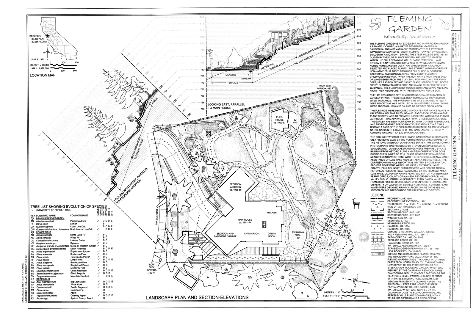
The Fleming Garden is a private, all-native residential garden on a hillside site that runs from about 750 feet to about 820 feet in elevation. Its section-elevation, looking east parallel to the main house, climbs from a meadow at 780 feet past a stream, a terrace and a waterfall, then labels the plant communities in long bands along the slope: coastal bluff, hillside garden, low-growing chaparral and tall chaparral. A plan cannot show that layering by height, and that is exactly how the garden was planned.
The HALS sheet tells the story behind the drawing. Scott Fleming, a lawyer by vocation and a builder by avocation, shaped the steep site from 1951 to 1955 and built the retaining walls, paths, waterfall and stream from 1956 to 1971. Jenny Fleming chose and placed the plants. When non-native fruit trees failed in the clay soil, fog, wind and deer, she turned to native horticulture, and the couple went on to help found and lead the California Native Plant Society.
The section also shows a garden under pressure. The sheet notes that trees were removed as they died or grew too large, that a deer fence installed in 1993 severed a path, and that the Flemings borrowed both landscape and land from their neighbours, with permission. The drawing earned an honorable mention in the Leicester B. Holland Prize in 2011 and is filed with the Library of Congress.
7. Kaiser Center Roof Garden (1960) – Oakland, USA
Landscape architects: Osmundson & Staley, design by David Arbegast | Area: about 150,000 sq ft | Below: a five-storey parking garage
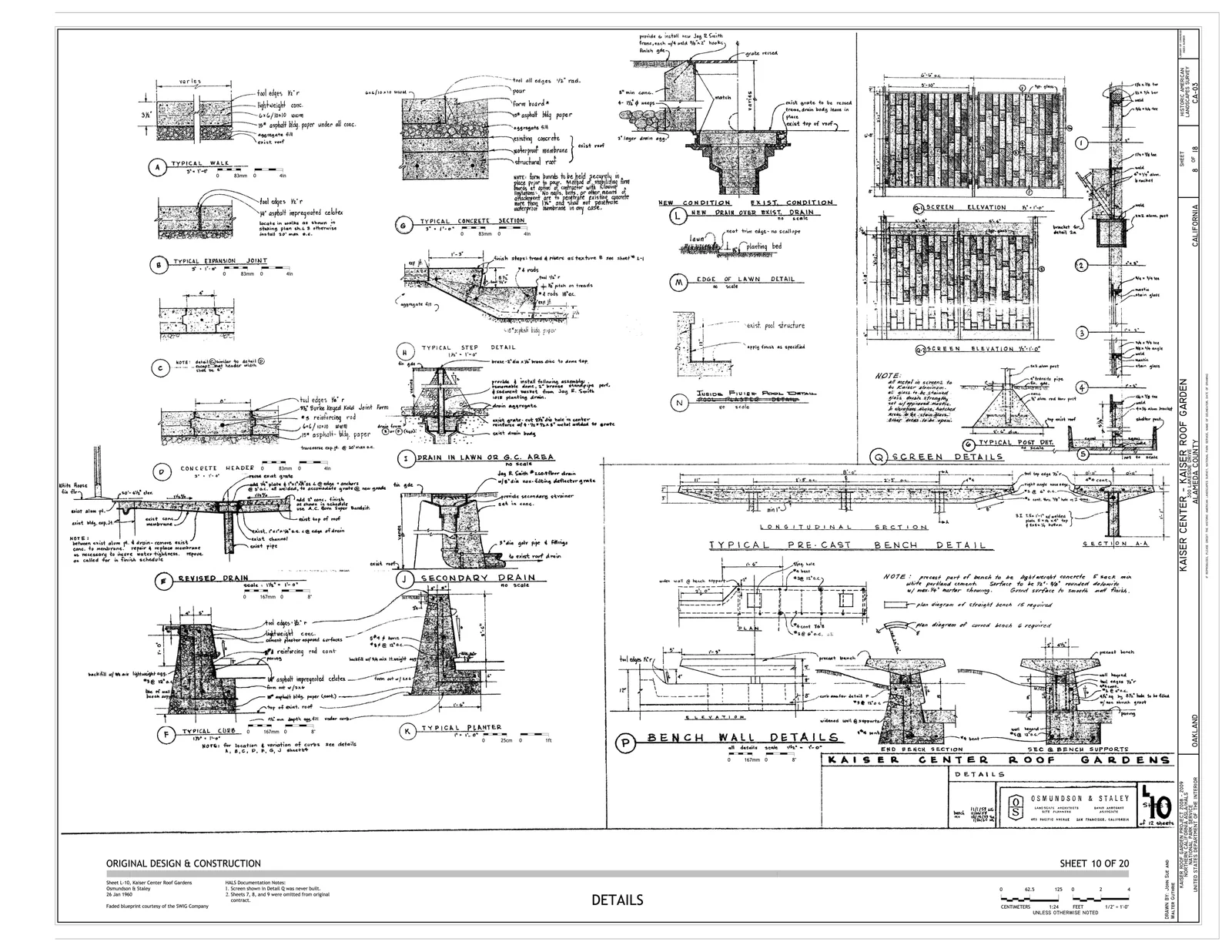
A roof garden is mostly invisible in plan, because its real design is the stack of layers under the lawn. This sheet, numbered L-10 and dated 26 January 1960 by Osmundson & Staley, is a set of small sections through exactly those layers. The typical concrete section shows, from the bottom up, the structural roof, the waterproof membrane, the existing concrete, an aggregate fill, asphalt building paper and the new pour. The typical planter and curb details call for backfill with lightweight aggregate and lightweight concrete.
The Cultural Landscape Foundation calls the garden the first true post-war rooftop garden in the United States, with 42 mature specimen trees, a reflecting pool and undulating lawns. Greenroofs.com lists drainage and weight as the main challenges, solved partly with downspouts at every other column that carry water down through the five levels of the garage. The sections show the same concern in a single note: no nail, bolt or other fixing may enter the existing concrete by more than 1 1/2 inches, and none may penetrate the waterproof membrane.
The drawing set is honest about what changed. The HALS notes on this sheet record that the screen shown in one detail was never built and that three sheets were omitted from the original contract. The Cultural Landscape Foundation lists the garden as at risk, and our overview of current uses of green roofs shows how far the idea has travelled since 1960.
💡 Pro Tip
In any section over a structure, draw and label the waterproofing and its protection as their own lines, even when they are only a few millimetres thick. The Kaiser sheet does this, and its fixing rule about the membrane is the kind of instruction contractors follow only when it is written directly on the section they are pricing.
8. Theodore Roosevelt Island Memorial (1967) – Washington, D.C., USA
Memorial architect: Eric Gugler | Sculptor: Paul Manship | Sections drawn by: Meghan Clemmens, Anne E. Kidd and Cal J. Mincey for the National Park Service (2007)

This HALS sheet draws the same memorial plaza three times. Section A3 cuts north to south through the plaza at 1:64, A2 repeats the cut at 1:128, and A1 continues all the way from the pedestrian footbridge to the plaza at 1:256, with a string of spot elevations measured from a datum of 100.00 at the footbridge base. Reading the three together, you see the plaza first as a room of benches, fountains and statue, then as a clearing in woodland, then as the end of a long, gently rising walk.
That sequence is the design. The Cultural Landscape Foundation describes how Frederick Law Olmsted Jr. and the Olmsted Brothers oversaw the island’s re-naturalization into mature woodland with help from the Civilian Conservation Corps, and how Gugler set an oval space with upper and lower terraces, a moat and a double hedge of willow oaks at its northern end. Paul Manship’s statue is seventeen feet tall and stands with four 21-foot granite stelae.
On the section those dimensions look small, which is the point: in the A1 cut the tree canopy is far taller than the statue, and the memorial reads as a pause inside a forest. The National Park Service manages the island today.
9. Skyline Park (1975) – Denver, USA
Landscape architect: Lawrence Halprin and Lawrence Halprin & Associates | Built: 1972 to 1975 | Size: one acre over three blocks
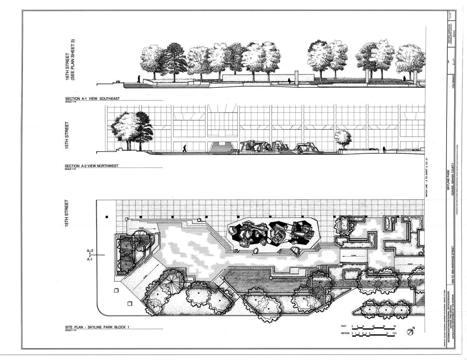
Skyline Park was a one-acre linear park in Denver’s Skyline Urban Renewal District, laid out over three blocks and sunk below street level, with one major water feature on each block. Zachary Peterson’s 2004 HALS sheet pairs the plan of Block 1 with two sections: A-1 looking southeast toward 16th Street and A-2 looking northwest toward 15th Street, where the concrete fountain sits low in the plaza in front of a glazed facade.
The sections explain both the appeal and the problem. The cut line shows how retaining walls, stepped seating walls, planters and stairs create the hollow, and how far the plaza floor sits below the pavement. That depth gave the park its enclosure, and it also meant that passers-by on the street saw little of what happened inside.
According to the Cultural Landscape Foundation, use of the park declined in the 1980s, and in 2003 much of it was redesigned: several walls and two of the fountains were kept, the berms were removed and other areas were replaced with a simpler planting palette and large lawns. The HALS sections were drawn as that change took place, so they are partly a record of a Halprin park that no longer exists in its original form.
10. Camp Curry (1899) – Yosemite Valley, USA
Founded by: David and Jennie Curry | Elevation: about 4,003 feet | Section drawn by: Jeremy T. Mauro, HALS CA-65 (2012)
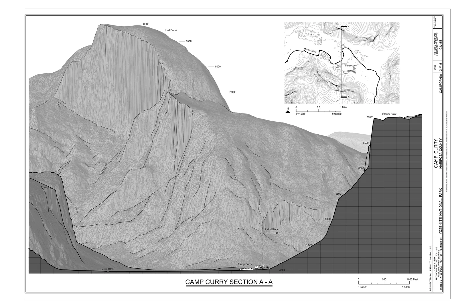
This is the largest section in the list. Drawn at one inch to 250 feet, section A-A crosses Yosemite Valley from the Merced River past Camp Curry to the cliff below Glacier Point at 7,000 feet, with Half Dome at 8,836 feet rising behind. The camp is a thin strip of cabins at the foot of the wall, and a dashed line marks the rockfall zone that runs straight into it.
The section exists because of that line. According to the Curry Village entry on Wikipedia, the camp sits on a talus cone of debris from old rockfalls. On 8 October 2008 a rockfall of about 6,000 cubic metres destroyed two hard-sided cabins and three tent cabins, and the park then permanently closed 233 visitor units and 43 concessioner housing units, about one third of the total. In 2011 the National Park Service decided to remove 72 buildings inside the hazard zone.
The Yosemite rockfall page records more than 1,000 rockfalls in the park over the past 150 years. A plan of the camp shows tidy rows of cabins; only the section shows a 3,000-foot cliff above them, which is the honest lesson of this drawing: it was made after the disaster it explains.
11. Hackney Housing Landscape by BBUK Studio (2020) – London, UK
Landscape architect: BBUK Studio | Planning permission: September 2020 | Borough: Hackney

BBUK Studio, a London practice set up in 2002 and chartered with the Landscape Institute, posted this detail from one of its sketch sections in September 2020, a week after its Hackney scheme received planning permission. The office explained that the existing games area was well used by local people and so was kept, with new play for younger children placed on lawns on either side. The section reads that decision from left to right: private back gardens, a path, then the fenced games area with benches, planting and trees around it.
The section is the right drawing for this argument because play space in London is judged partly by what overlooks it. London Plan Policy S4 asks residential schemes for at least 10 square metres of play space per child, overlooked to enable passive surveillance. In section, the windows of the housing block, the low garden fences and the games area sit in one view, which shows who can see the play space.
As a record it is thin. The post does not name the estate, and the sketch carries no levels, so it explains the relationship between gardens and play but not the build. Our article on playgrounds in landscape architecture looks at the same question in plan.
12. IPB University Graduate School Landscape Redesign – Bogor, Indonesia
Campus: IPB University Dramaga Campus, 267 ha | Drawing: section of the water side promenade | Posted: February 2023 by @l.andarch
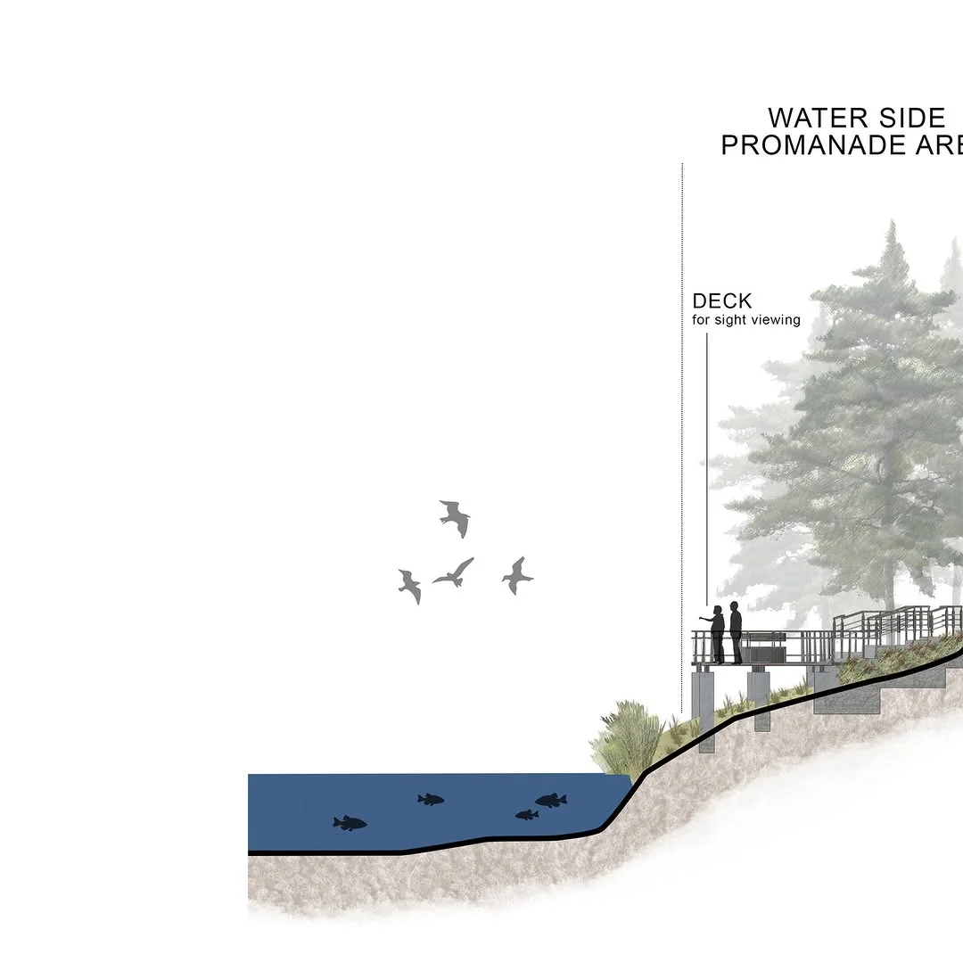
The newest drawing in the list is a section from a landscape redesign for the Graduate School on IPB University’s Dramaga campus in Bogor. IPB describes the campus as 267 hectares, home to its rectorate and its undergraduate and graduate teaching, and according to the IPB University entry on Wikipedia, it opened the first graduate school in Indonesia in 1975. The university also runs its own Department of Landscape Architecture.
The section cuts through a water side promenade. A timber deck “for sight viewing” stands on posts over a planted bank, with a railing and steps climbing the slope behind it, tall trees in the background and fish drawn in the water. Setting the deck on posts rather than on fill is a decision only a section can make visible: the bank and its planting continue underneath, and the water line stays where it was.
The posted image has clear gaps. It shows only half of the section, gives no dimensions or levels, and names the account rather than a designer. It is still a good example of how much a section can say with one ground line and one structure.
Honorable Mentions
Embrace Co-housing – Burnley, UK
This long section from a Manchester School of Architecture student project runs from the water’s edge past play areas and terraced gardens to co-housing for single parents in Burnley recovering from substance abuse. It stays outside the main list because most of its work is done by the buildings rather than the ground.
Watersquare Benthemplein (2013) – Rotterdam, Netherlands
De Urbanisten designed this square with two shallow basins for the immediate surroundings and one deeper basin, so that it fills in stages during heavy rain. Its sections are well known, but no openly licensed version was available for this list.
Schloss Gaibach Plan and Section – Bavaria, Germany
The same Rijksmuseum series that holds the Weißenstein sheet includes a plan and cross-section of Schloss Gaibach. It is left out because it repeats the drawing method of the first entry.
Patterns Across the Twelve Landscape Sections
The ground line carries the argument
The Swan House section is about a 55-foot fall, the Fleming Garden about a 70-foot climb, and Camp Curry about a valley wall more than 3,000 feet high. In each case the most important line on the sheet is the ground itself, and the design only makes sense once that line is drawn accurately. The Arneson River Theater shows the same thing at a smaller scale, with seating tiers that exist only because the River Walk sits twenty feet below the street.
What lies below decides what can grow
The Kaiser Center sheet and the Canal Saint-Martin section both put the critical information under the surface: a waterproof membrane in one case, a masonry vault in the other. Crater Rim Drive adds culverts, filled cracks and hidden stone shoulders. These are the sections that a contractor and a horticulturist both need, because soil depth and structure fix what planting is possible long before any species is chosen.
More than one scale on a sheet
Theodore Roosevelt Island draws one plaza at three scales, Weißenstein ties a plan and a profile to one scale bar, and Skyline Park sets its sections directly above the plan they cut. The pairing lets a reader move from overall shape to detail without changing sheets, which is the habit our guide to reading a graphic scale encourages.
Documentation sections record change
Many of the strongest drawings here were made after the fact. Skyline Park was measured as it was being redesigned, the Swan House sheet admits that no as-built drawings survive, Camp Curry was drawn after the 2008 rockfall and Crater Rim Drive has since been partly buried by tephra. A measured section is often the only lasting record of a landscape that keeps moving.
Frequently Asked Questions
Which landscape section in this list shows the largest change in level?
Camp Curry. Its section A-A runs from the floor of Yosemite Valley at about 4,000 feet to the cliff below Glacier Point at 7,000 feet, with Half Dome at 8,836 feet behind. The Swan House, by comparison, falls 55 feet over 366 feet of section.
Which is the oldest drawing in the list?
The Schloss Weißenstein profile, engraved after drawings Salomon Kleiner made between 1723 and 1726. The next oldest is the Canal Saint-Martin basin section from February 1860. The newest is the IPB University promenade section, posted in 2023.
Which sections show what is hidden under the surface?
The Kaiser Center Roof Garden details show the structural roof, waterproof membrane and lightweight fill under the planting, and the Canal Saint-Martin section shows the vault and water level beneath the boulevard. The Arneson River Theater section also draws the river bed below the waterline.
Where to Go From Here
Your Next Step: Pick one site you know well, find its highest and lowest points, and draw a single landscape architecture section between them with datum lines every metre, the ground line drawn heavier than anything else and the soil below it labelled. If you need a starting point for reading slopes, our notes on site topography and the schools listed in our guide to landscape architecture schools are good places to continue.




Landscape Architecture Drawings: Plans, Sections and Diagrams Explained with Real Examples
Seven real landscape architecture drawings, one for each type: the Emerald Necklace...
illustrarch Editoral Team11 Mins read

Top Rated Landscape Architecture Schools in the US, Europe, and Beyond
From Harvard GSD and UC Berkeley to Wageningen University in Europe, the...
 Sinan Ozen10 Mins read

Top 10 Landscape Architecture Books Every Designer Should Read
A focused guide to ten landscape architecture books covering ecology, planting design,...
 Bahattin Duran6 Mins read

7 Powerful iPad Apps for Modern Landscape Architecture & Garden Design
In 2025, iPad-based workflows have become essential for landscape architects and garden...
Bahattin Duran10 Mins read


Leave a comment