

4 Ways Architects Are Using Drones Beyond Site Surveys
Drones have moved well past simple site surveys in architecture. This article covers four practical applications that architecture firms are adopting right now, including facade inspections, photogrammetric 3D modeling, real-time construction monitoring, and landscape analysis, with real project examples, cost data, and industry statistics.

Table of Contents Show
An architecture drone is no longer limited to capturing aerial photos of a construction site before work begins. Firms worldwide now deploy drones for facade inspections, photogrammetric 3D modeling, real-time construction progress tracking, and landscape analysis, reducing costs and improving accuracy at every project stage.
Most architects first encountered drone technology through basic site surveys: fly over a parcel, snap some photos, stitch together an overhead map. That was useful, but it only scratched the surface. Today, the global construction drone market is valued at roughly $5.1 billion (Straits Research, 2024) and is expected to grow at a compound annual rate of around 12% through the early 2030s. The growth is not coming from more site surveys. It is coming from entirely new workflows that drones enable across design, construction, and post-occupancy phases. The four applications below represent the areas where architecture firms are seeing the strongest return on investment right now.
Drone-Assisted Facade and Building Inspections
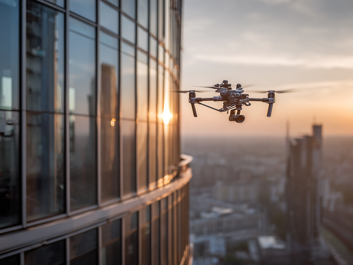
Inspecting a building facade has traditionally meant scaffolding, swing stages, or rope-access teams. Each option is expensive, slow, and carries safety risks. A drone equipped with a high-resolution zoom camera or thermal sensor can document an entire facade in hours rather than days, at a fraction of the cost.
The practical difference is significant. A full four-sided drone facade inspection of a mid-rise building (10 to 20 stories) typically costs between $3,000 and $10,000, compared to $15,000 or more for scaffolding-based methods. Beyond cost savings, drones reach areas that are physically difficult or dangerous for human inspectors, including parapets, setbacks, and upper-floor corners where cladding failures often begin.
Thermal imaging payloads add another layer. A thermal camera mounted on a drone can detect moisture intrusion behind cladding, insulation gaps, and air leakage paths that are invisible to the naked eye. For firms working on renovation or adaptive reuse projects, this data directly informs design decisions about where the existing envelope needs intervention.
💡 Pro Tip
When planning a drone facade inspection, schedule the thermal scan for early morning or late afternoon. Temperature differentials between building surfaces and the surrounding air are greatest during these periods, making moisture infiltration and insulation defects far easier to detect on thermal imagery.
In cities with mandatory facade inspection programs, such as New York’s Facade Inspection and Safety Program (FISP), drone data is now routinely used to support the engineer’s compliance filings. The orthomosaic facade maps that drones produce give inspectors a geometrically corrected, annotated record of every visible defect, complete with GPS coordinates and severity ratings.
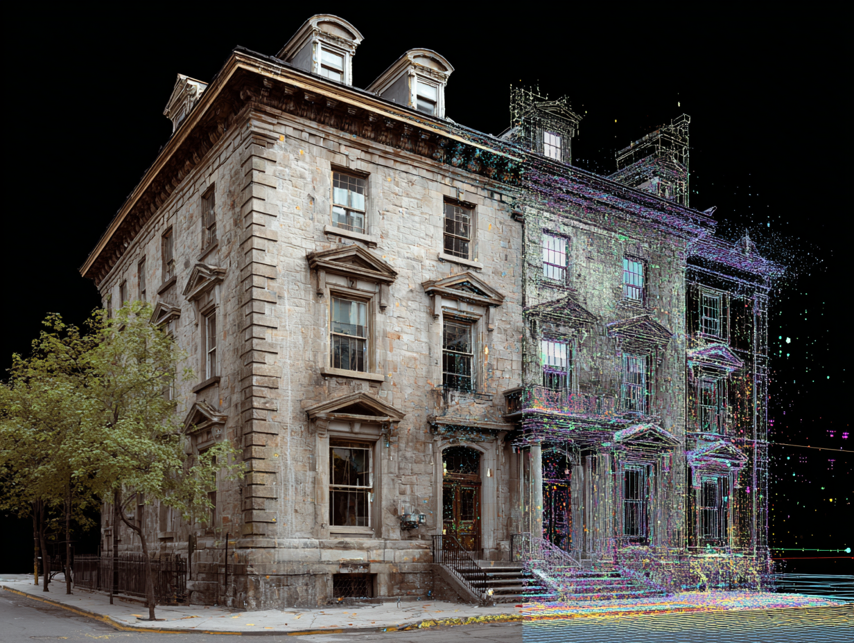
Photogrammetric 3D Modeling and Digital Twins
Photogrammetry uses overlapping aerial photographs to reconstruct the three-dimensional geometry of a building or site. A drone flying a pre-programmed path around a structure captures hundreds or thousands of images, and software such as DroneDeploy, Pix4D, or Agisoft Metashape processes them into point clouds, textured 3D meshes, and orthomosaics.
For architects, the output is immediately useful. A photogrammetric model of an existing building can be imported into Revit, ArchiCAD, or Rhino as a reference for renovation design, clash detection, or as-built documentation. When paired with LiDAR sensors, the accuracy improves to 1 to 3 centimeters, which is sufficient for most architectural detailing work.
The connection to architectural technology workflows is direct. Drone-captured point clouds feed into BIM models, creating a digital twin of the existing structure. This digital twin then serves as the baseline for design iterations, structural analysis, and coordination with engineers and contractors. The result is fewer surprises during construction and a more accurate set of documents from day one.
🎓 Expert Insight
Research from iScano and similar reality-capture firms indicates that integrating drone-generated 3D meshes into BIM software like Revit or Navisworks for automated clash detection can reduce design errors by approximately 30% and compress project timelines by around 20%.
Heritage and conservation projects benefit especially from this approach. Capturing a historic facade with photogrammetry preserves a dimensionally accurate record of the building’s current state before any intervention. If a stone cornice or decorative element needs to be replaced, the 3D model provides exact geometry for fabrication.
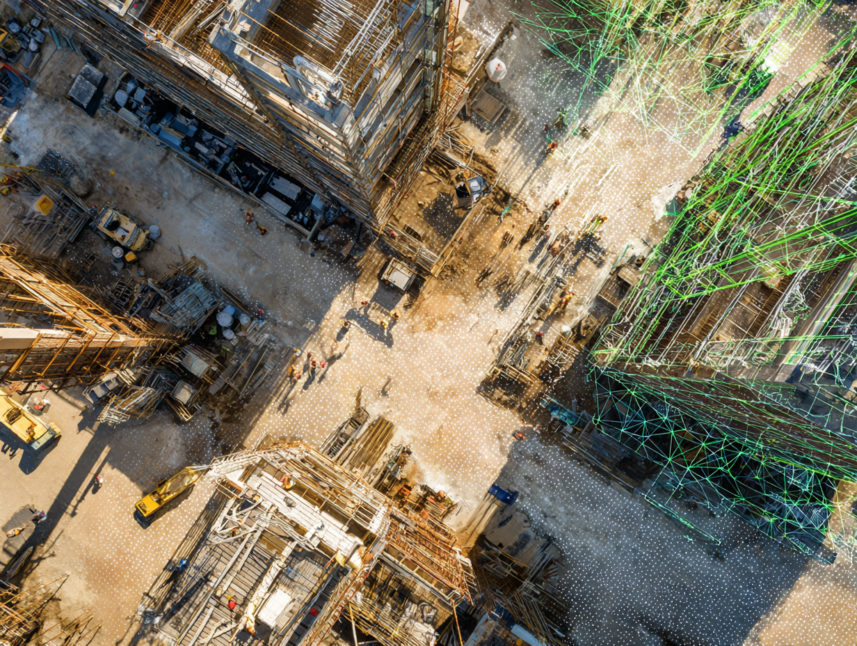
How Do Drones Help With Real-Time Construction Monitoring?
Drones equipped with GPS-tagged cameras fly over active construction sites on a regular schedule, sometimes daily, sometimes weekly, and capture a complete visual record of progress. This imagery is processed into orthomosaic maps, 3D models, and volumetric measurements that project managers compare against the design model and the construction schedule.
The value here is accountability and speed. Rather than relying on a superintendent’s verbal update or a handful of ground-level photos, the project team gets an objective, measurable snapshot of the entire site. Deviations from the plan, whether a misaligned foundation wall or an earthwork volume that does not match the grading design, show up in the data before they become expensive fixes.
According to a 2024 US Construction Survey cited by SNS Insider, 45% of civil contractors in the United States have fully integrated drones into their daily workflows, with that figure rising to 67% among larger firms. The same data indicates that drone-assisted measurement accuracy improved by 61% compared to manual methods, while data acquisition time dropped by 53%.
🔢 Quick Numbers
- The global construction drone market was valued at $5.1 billion in 2024 and is projected to reach roughly $12.5 billion by 2030 (Mordor Intelligence, 2025)
- 45% of US civil contractors have fully integrated drones into workflows, rising to 67% for large firms (US Construction Survey, 2024)
- Drone-based facade inspections can reduce survey budgets by 60% to 80% compared to scaffolding methods (iScano, 2026)
Time-lapse documentation is another practical output. By capturing imagery at consistent intervals throughout a project, drones create a visual archive that supports dispute resolution, insurance claims, and client reporting. Several firms now embed drone-captured progress data directly into their project management platforms, linking each aerial capture to the corresponding phase of the BIM model.
Video: How Drones Support Construction Photogrammetry and Mapping
This video from DroneDeploy covers how drone surveying and photogrammetry work on active construction sites, including mapping workflows and data processing techniques used by AEC professionals.
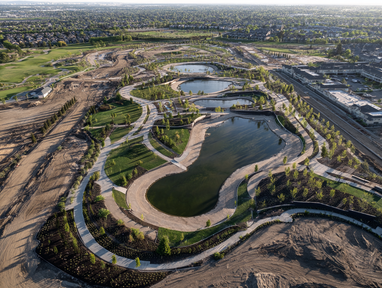
Drone Landscape Architecture and Environmental Analysis
Landscape architects use drones for tasks that go well beyond pretty aerial photographs. Multispectral sensors mounted on drones capture data about vegetation health, soil moisture, and canopy density across large sites. This information feeds directly into planting plans, stormwater management designs, and environmental impact assessments.
For large-scale projects such as campus masterplans, parks, or waterfront developments, a single drone flight can produce a topographic survey, a vegetation health map (using NDVI indices), and a high-resolution orthomosaic, all in one session. The same data that took a survey crew multiple days to gather manually now arrives in a few hours, with higher resolution and consistent georeferencing.
Landscape architecture workflows increasingly rely on GIS-integrated drone data. A drone-captured digital elevation model helps designers understand water flow patterns across a site, identify low spots prone to flooding, and design grading solutions that work with the natural terrain rather than against it. For sustainability-focused projects, drone-captured baseline data also makes it possible to measure the environmental impact of a design intervention over time by comparing pre-construction and post-construction imagery.
💡 Pro Tip
If you are flying a drone for vegetation analysis, use a multispectral sensor rather than a standard RGB camera. NDVI (Normalized Difference Vegetation Index) data from a multispectral sensor reveals stressed or dying vegetation that looks perfectly healthy in a regular photograph, helping landscape architects make better planting and irrigation decisions.
🏗️ Real-World Example
Hudson Yards, New York (2019): During the development of the Hudson Yards public plaza and landscape, drones were used extensively for construction progress monitoring and topographic surveying of the platform built over active rail yards. The aerial data allowed landscape architects and engineers to coordinate planting, drainage, and structural loading on a site where traditional ground-level surveying was impractical due to the active rail infrastructure below.
What Should Architecture Firms Consider Before Adopting Drones
The technology is accessible, but adoption still requires planning. The first consideration is regulatory compliance. In the United States, commercial drone operations fall under FAA Part 107 rules, which require a Remote Pilot Certificate. Similar frameworks exist in the EU under EASA regulations and in other jurisdictions worldwide. Flying in urban areas near buildings often involves airspace restrictions that require additional waivers.
Cost is the second factor. Enterprise-grade drones equipped with LiDAR, thermal imaging, and AI-powered analytics range from $10,000 to $50,000 per unit, plus ongoing costs for software subscriptions, maintenance, and pilot training. For smaller firms, outsourcing drone operations to a specialized service provider is often more cost-effective than building an in-house program.
Data management is the third challenge. A single drone flight can generate gigabytes of imagery and point cloud data. Firms need a clear workflow for processing, storing, and integrating this data with their existing BIM and project management systems. Platforms like DroneDeploy, Pix4D, and Autodesk construction cloud offer integrations that simplify this pipeline, but setting them up requires upfront investment in training and infrastructure.
⚠️ Common Mistake to Avoid
Many firms purchase a drone and assume any staff member can operate it effectively. Flying for architectural data capture requires specific skills: understanding overlap percentages for photogrammetry, managing flight altitudes for consistent ground sample distance, and operating safely near structures. Investing in proper pilot training and mission planning software is as important as the hardware itself.
✅ Key Takeaways
- Architecture drone applications now extend well beyond site surveys into facade inspection, 3D modeling, construction monitoring, and landscape analysis.
- Drone-based facade inspections can cut survey costs by 60% to 80% compared to scaffolding or rope-access methods, while improving safety.
- Photogrammetric 3D models from drone imagery integrate directly into BIM workflows, creating accurate digital twins for renovation and new construction projects.
- Real-time construction monitoring with drones gives project teams objective, measurable progress data that reduces disputes and catches deviations early.
- Regulatory compliance, pilot training, and data management infrastructure are essential prerequisites before any firm adopts drone technology.
Final Thoughts
The architecture drone is no longer a novelty or a marketing gimmick. It is a working tool that delivers measurable value across multiple project phases. Firms that treat drones as data-collection platforms, not just cameras in the sky, are the ones extracting the most benefit. The four applications covered here represent the current state of practice, but the trajectory is clear: as sensors get smaller, software gets smarter, and regulations evolve, the role of drones in architecture will only expand.
The firms gaining a competitive advantage are not waiting for the technology to mature further. They are building drone workflows into their standard practice now, training their teams, and treating aerial data as a core project deliverable rather than an optional add-on. For architecture practices of any size, the question is no longer whether to adopt drones, but how quickly to integrate them into the way the firm works.
How much does a drone cost for an architecture firm?
Entry-level mapping drones suitable for basic photogrammetry start at around $1,500 to $3,000. Enterprise models with LiDAR, RTK positioning, and thermal sensors range from $10,000 to $50,000. Many smaller firms find that hiring a drone service provider for specific projects costs less than maintaining an in-house fleet, especially when factoring in pilot certification, insurance, and software licenses.
Do architects need a license to fly drones?
Yes, in most jurisdictions. In the United States, any commercial drone operation requires a Part 107 Remote Pilot Certificate from the FAA. The EU follows EASA drone regulations with operator registration and competency requirements. Even if an architect hires a third-party pilot, the firm should verify that the operator holds the correct certifications and insurance for commercial operations.
Can drone data be integrated with BIM software?
Yes. Point clouds and 3D meshes generated from drone photogrammetry or LiDAR scans can be imported into BIM platforms like Revit, ArchiCAD, and Vectorworks. Software such as DroneDeploy, Pix4D, and Autodesk ReCap handle the conversion from raw drone imagery to BIM-compatible formats. This integration allows architects to overlay existing conditions data directly onto their design models for clash detection and as-built verification.
What are the main limitations of drones in architecture?
Battery life remains a constraint, with most commercial drones offering 30 to 45 minutes of flight time per charge. Weather conditions, particularly wind and rain, limit when drones can fly. Urban airspace restrictions in dense cities can require special waivers. Data processing for large photogrammetric models demands significant computing power. Privacy concerns around flying cameras near occupied buildings also require careful management and communication with stakeholders.


Top Questions to Ask an Electrician in Fort Mill Before Starting a Project
The right questions to ask an electrician in Fort Mill before a...

Shear Wall Examples in Architecture: Types, Placement and Design
A practical guide to shear walls in architecture covering concrete, steel, plywood,...

Adaptive Reuse Architecture vs New Construction: A Practical Cost, Sustainability, and Design Comparison
A practical comparison of adaptive reuse architecture and new construction across cost,...

What Is a Curtain Wall in Architecture? Types, Design and Construction
Curtain walls are non-load-bearing facade systems that hang from a building's structural...

Leave a comment