

Landscape Master Plan Examples: 10 Parks, Waterfronts and Campuses
Ten real landscape master plans, from the 1862 Bois de Boulogne sheet and Prospect Park to Bénard's Berkeley campus, the McMillan Plan and a 2024 Newhaven seafront, read for the decisions they fixed and where they fell short.
 illustrarch Editoral Team25 October 202614 Mins read1

Table of Contents Show
A landscape master plan is the large-scale drawing that fixes how land, water, movement and buildings fit together across a whole park, campus or waterfront before any part is designed in detail. It sets the structure, phasing and boundaries, so later site plans, planting plans and details all follow one agreed framework.
The ten examples below are real plans, from the 1862 sheet for the Bois de Boulogne in Paris to a seafront scheme approved in Newhaven in 2024. Six are historic public domain drawings, four are recent office and competition sheets shared on Instagram. Each one is read for the decision it fixes, the number that explains it, and where the plan and the ground later went separate ways.
What Is a Landscape Master Plan?
A landscape master plan answers one question: how does a large piece of land work as a system? It shows the big moves, such as lakes, main routes, building zones and open fields, at a scale where a whole park or district fits on one sheet. It does not specify a single bench or shrub.
That separates it from two neighbouring drawings. A garden master plan does the same job for a private garden, and our article on why good garden design starts with a masterplan covers that scale. A site plan works one step closer, placing every element on a single plot, which our practical guide to the architectural site plan explains. The plans in this list sit above both, at the scale of parks, campuses and waterfronts.
The 10 Master Plans at a Glance
The table gives the year of each sheet, the type of place it organises and one figure that shows its scale.
| Master plan | Year | Type | Key figure |
|---|---|---|---|
| Bois de Boulogne, Paris | 1862 | Forest park | 845 hectares |
| Parc des Buttes-Chaumont, Paris | 1867 | Urban park on a quarry | 24.7 hectares |
| Prospect Park, Brooklyn | 1870 | Urban park | 526 acres |
| Jackson Park, Chicago | 1895 | Lakefront park | 551.5 acres |
| Phoebe Hearst Plan, Berkeley | 1899 | Campus | 11 finalists judged |
| McMillan Plan, Washington | 1901 | Civic core and park system | Mall narrowed to 300 feet |
| University of Arkansas, Fayetteville | 1925 | Campus | 71-acre historic district today |
| Hersted Industrial Park, Herstedøster | 2012 | Industrial district | 170-hectare winning masterplan |
| Frederica, St. Simons Island | Undated | Golf and residential community | 1,700 acres |
| West Beach, Newhaven | 2024 | Seafront | 378 m² restaurant |
1. Bois de Boulogne (1862) – Paris, France
Area: 845 hectares | Ceded to the city: 1852 | Plan issued by: Service municipal des travaux publics de Paris
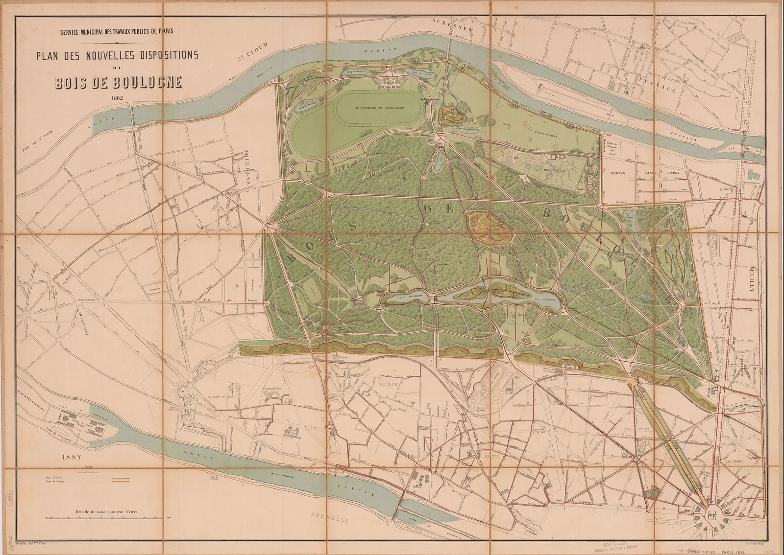
The 1862 “Plan des nouvelles dispositions du Bois de Boulogne” records the conversion of a large wooded estate on the western edge of Paris, now the western half of the 16th arrondissement, into a public park. According to the Bois de Boulogne entry on Wikipedia, Napoleon III ceded the land to the city in 1852 and wanted streams and lakes like those of Hyde Park, which had impressed him during his exile in London. The sheet shows the result at a glance: straight older avenues overlaid by curving carriage drives, two lakes in the middle and the Hippodrome de Longchamp, opened in 1857, at the northern edge by the Seine.
The plan also hides a correction. The first designer, Louis-Sulpice Varé, laid out a single stream without allowing for the difference in level across the site, so the water would not flow. The fix was an upper and a lower lake divided by a raised road, and the drawing still shows them as two pieces. The redesign passed to Jean-Charles Alphand, whose team planted 420,000 trees and built 58 kilometres of carriage roads, figures that explain why the plan reads as a dense green field threaded with drives.
💡 Pro Tip
Put spot levels on the master plan before you draw any water. Varé’s stream at the Bois de Boulogne failed on paper as well as on site, and a few levels along the line of the stream would have shown the problem before construction began.
2. Parc des Buttes-Chaumont (1867) – Paris, France
Area: 24.7 hectares | Opened: 1 April 1867 | Team: Jean-Charles Alphand, Jean-Pierre Barillet-Deschamps, Gabriel Davioud

Buttes-Chaumont shows a master plan written over damaged ground. The site in north-eastern Paris had been a gypsum and limestone quarry, a refuse dump and, much earlier, the site of the Montfaucon gibbet. Alphand’s team cut a 1.5 hectare lake and left a 50 metre rock island in it, crowned by the small temple designed by Gabriel Davioud. On this watercolour plan, the drives loop around the lake in long curves that take the slopes at an angle instead of head on, and the paths between them are left to climb the steep ground on foot.
The quarry never went away. The City of Paris describes cracks, sinkholes and subsidence caused by leaks dissolving the gypsum below, and lists 12 million euros already spent on maintenance and renovation, with a further 6 million euros planned. Preparatory work runs from October 2026 to the end of March 2027, while 95 percent of the park stays open. The 1867 plan solved the shape of the site; it could not solve what lay under it.
If you are comparing it with other city parks, our list of the world’s best urban parks places it among its peers.
3. Prospect Park (1870) – Brooklyn, New York, USA
Designers: Frederick Law Olmsted and Calvert Vaux | Area: 526 acres | Long Meadow: 90 acres
The 1870 “Design for Prospect Park in the City of Brooklyn” is a park master plan in its purest form; the Wikimedia Commons record describes it as one of the first published maps to focus on the design of the park. Frederick Law Olmsted and Calvert Vaux organise the triangle into three landscapes: the 90-acre Long Meadow to the north, the wooded Ravine in the middle and a 60-acre lake to the south. Drives run around the edge, so the meadow in the middle stays unbroken, a choice that turns a city block system into a single view.
Look at the lower right corner and the sheet tells a second story. Ground beyond Flatbush Avenue is marked “Ground reserved for public buildings”, and the blocks beside it are labelled “For sale”. According to the Prospect Park entry on Wikipedia, land from the 1860 proposal now holds the Brooklyn Museum, Brooklyn Public Library and Brooklyn Botanic Garden. The master plan was also a land deal.
The park’s later history is the critical part. By 1979 attendance had fallen to two million a year, the lowest on record, and a 1974 report found that 44 percent of city residents would warn people to stay away. The Prospect Park Alliance, founded in 1987, has since restored much of the Olmsted and Vaux design.
📌 Did You Know?
Olmsted and Vaux planned sheep into the Long Meadow. According to the Prospect Park Alliance, sheep grazed the meadow until the 1930s, giving the park a pastoral image and doing the work of a lawnmower at the same time.
4. Jackson Park (1895) – Chicago, USA
Designers: Olmsted, Olmsted and Eliot | Area: 551.5 acres | Superintendent of planting: Warren H. Manning
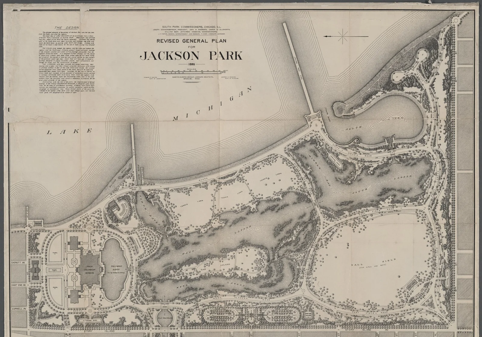
Jackson Park has three master plans in one site, and this is the third. Olmsted and Vaux designed it in 1871, Olmsted reshaped it for the 1893 World’s Columbian Exposition, and after a fire destroyed most of the fair buildings, the 1895 “Revised General Plan” turned the fairground back into a park. The text panel at top left names the plan’s three elements, the Lake, the Fields and the Lagoons, and the drawing follows that order from the Lake Michigan shore inland.
The title block credits Warren H. Manning as superintendent of planting. The dense tree masses drawn along the lagoons are what make the plan work: they hide the edges of each water body, so a boat moving through the lagoons gets a changing sequence of views. The fair’s Palace of Fine Arts, shown on the plan as the Field Columbian Museum, survives today as the Museum of Science and Industry.
The plan is still contested. The Cultural Landscape Foundation argued in 2018 that Chicago had taken more than 20 acres of the park for the Obama Presidential Center, and that its 220-foot tower broke Olmsted’s rule that buildings be subordinate to the scenery. The legal challenges took four years to resolve before ground was broken in September 2021.
5. Phoebe Hearst Architectural Plan (1899) – Berkeley, California, USA
First prize: Émile Bénard | Finalists: 11 | Original campus: 160 acres
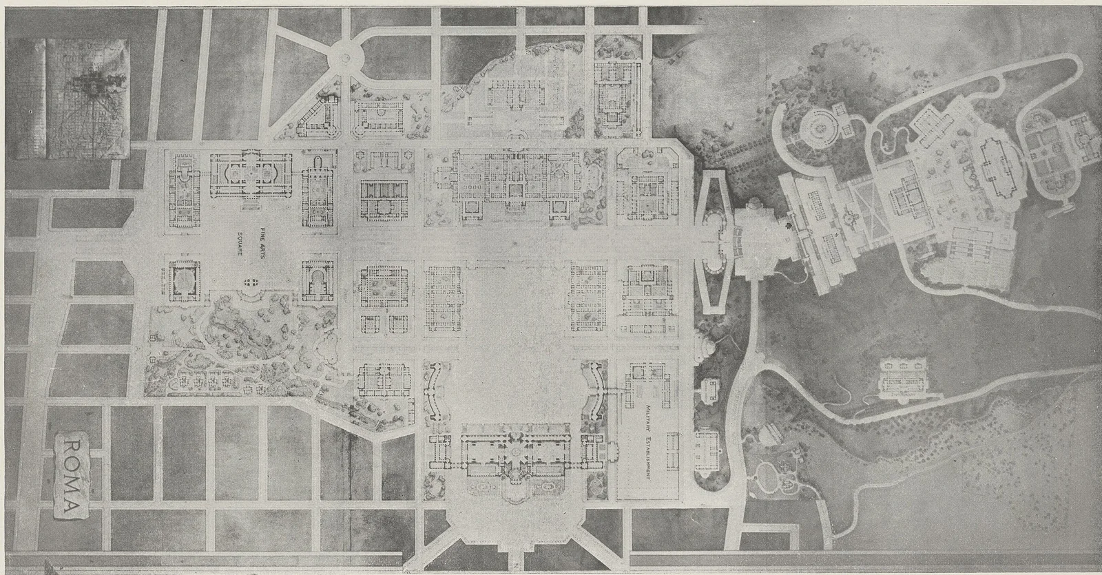
The University of California chose its campus master plan through an international competition paid for by Phoebe Apperson Hearst. A first round was judged in Antwerp in 1898, and 11 finalists were judged again in San Francisco in 1899. The jury report, signed on 7 September 1899 by J. L. Pascal, John Belcher, Paul Wallot, Walter Cook and J. B. Reinstein, gave first prize to the Parisian architect Émile Bénard, whose entry carried the motto “Roma”.
The general plan explains the motto. A single east to west axis runs from the city grid up into the hills, with formal courts and a great central space along it, while the eastern end dissolves into curving roads and planted slopes. The landscape is the transition between a Beaux-Arts city and the Berkeley hills.
The plan was never built as drawn. Bénard declined to supervise the work, and in 1901 the post went to John Galen Howard, who had placed fourth. Howard was told to follow Bénard’s plan without substantial change, then altered it until it was more his than Bénard’s, adding buildings such as the 307-foot Sather Tower. Our look at how campus architecture has evolved picks up the story from there.
6. McMillan Plan (1901) – Washington, D.C., USA
Commission: Daniel Burnham, Charles McKim, Frederick Law Olmsted Jr., Augustus Saint-Gaudens | Report: 15 January 1902 | Mall width: 300 feet
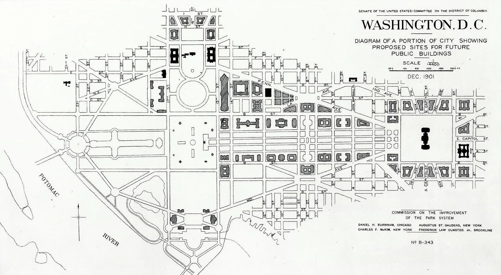
The Senate Park Commission, chaired by Senator James McMillan, was formed on 8 March 1901. Its December 1901 diagram, drawn at 1:14,400, shows the move that defines central Washington today: an open, cruciform Mall from the Capitol to the Potomac, framed by public buildings and lines of trees. The McMillan Plan entry on Wikipedia records that the Mall was narrowed to 300 feet, and that 71 pages of the report covered the Mall while the remaining 100 pages covered the wider park system.
The decisive change was not a tree or a building but a railway. The plan removed the Baltimore and Potomac station from the Mall, and Congress passed the legislation for Union Station on 15 May 1902, north of the Capitol. Without that, the open lawn on the diagram could not exist.
The plan had a cost. The Cultural Landscape Foundation notes that it was never formally adopted and that the outer park system fell to a cash-strapped local government. It also replaced the winding Victorian landscape of Andrew Jackson Downing with an open lawn, so one landscape master plan erased another.
7. University of Arkansas Campus Plan (1925) – Fayetteville, Arkansas, USA
Architects: Jamieson and Spearl, St. Louis | Sheet: Group Plan, Sketch No. C1, October 1925 | Historic district today: 71 acres
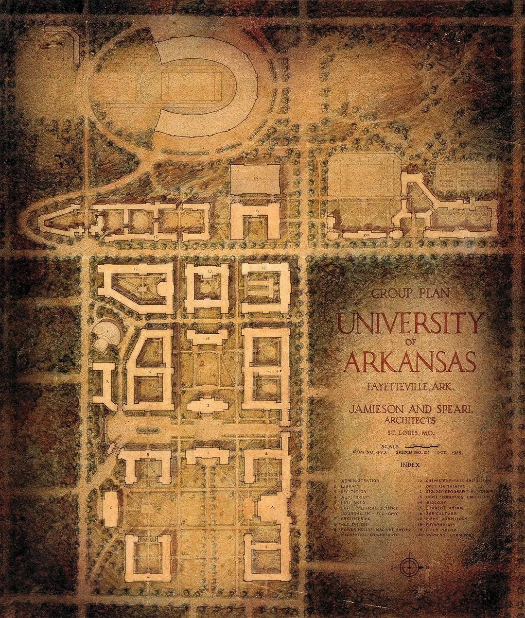
The “Group Plan” for the University of Arkansas is a campus master plan drawn as a set of quadrangles. The St. Louis firm Jamieson and Spearl proposed that every future building be Collegiate Gothic and placed to form courtyards, with a stadium and playing fields at one end of the sheet. The landscape in the sheet is simple, lawns and lines of trees, because the courts themselves were meant to do the work.
The ambition was total. According to the University of Arkansas Libraries, the plan expected existing buildings to be demolished and rebuilt in the new style. Funding ran dry, which is why Old Main, built between 1873 and 1875, is still standing. The parts that were built, such as the Agriculture Building and Engineering Hall in 1927 and the Chemistry Building in 1935, now sit in a 71-acre historic district listed in 2009. The campus has since grown to 378 buildings on 512 acres, guided since 1998 by a master plan from Sasaki.
8. Hersted Industrial Park Masterplan (2012) – Herstedøster, Denmark
Team: Brisac Gonzalez Architects with MAXWAN | Status: shortlisted competition entry | Municipality: Albertslund
Hersted Industrial Park, built in the 1960s west of Copenhagen, is the kind of district a landscape masterplan is now asked to fix: production, storage and logistics buildings that no longer suit modern business. In 2012 Albertslund Municipality ran an architecture competition with Realdania under its Future Suburbs programme. The shortlisted entry by Brisac Gonzalez Architects with MAXWAN, listed on Archello, sells its idea through two street-level renders: a timber walkway for cyclists through the business park, and a lawn with a lake and walking paths.
Those images are the point of the entry. Instead of a colour-coded zoning plan, the team shows what the landscape would feel like, which is a common strategy for shortlisted competition boards. The first prize went to another team, SLETH with Norconsult and Kristine Jensen, whose masterplan covered 170 hectares.
The competition did not deliver on its own timetable. The municipality’s Masterplan Hersted 2045 admits that, with business still recovering from the financial crisis, the timing in 2013 was not right and the investment did not come. A new masterplan with 11 new quarters only followed in 2019, after 33 workshops with landowners in 2018.
💡 Pro Tip
On a competition board, pair every hero render with a small plan that marks where the view was taken. Juries read renders first, but they award plans they can check, and the Hersted result shows how a strong image can still lose to a clearer masterplan.
9. Frederica Golf Club Clubhouse Area – St. Simons Island, Georgia, USA
Planner: EcoPlan | Community: 1,700 acres | Golf course: Tom Fazio
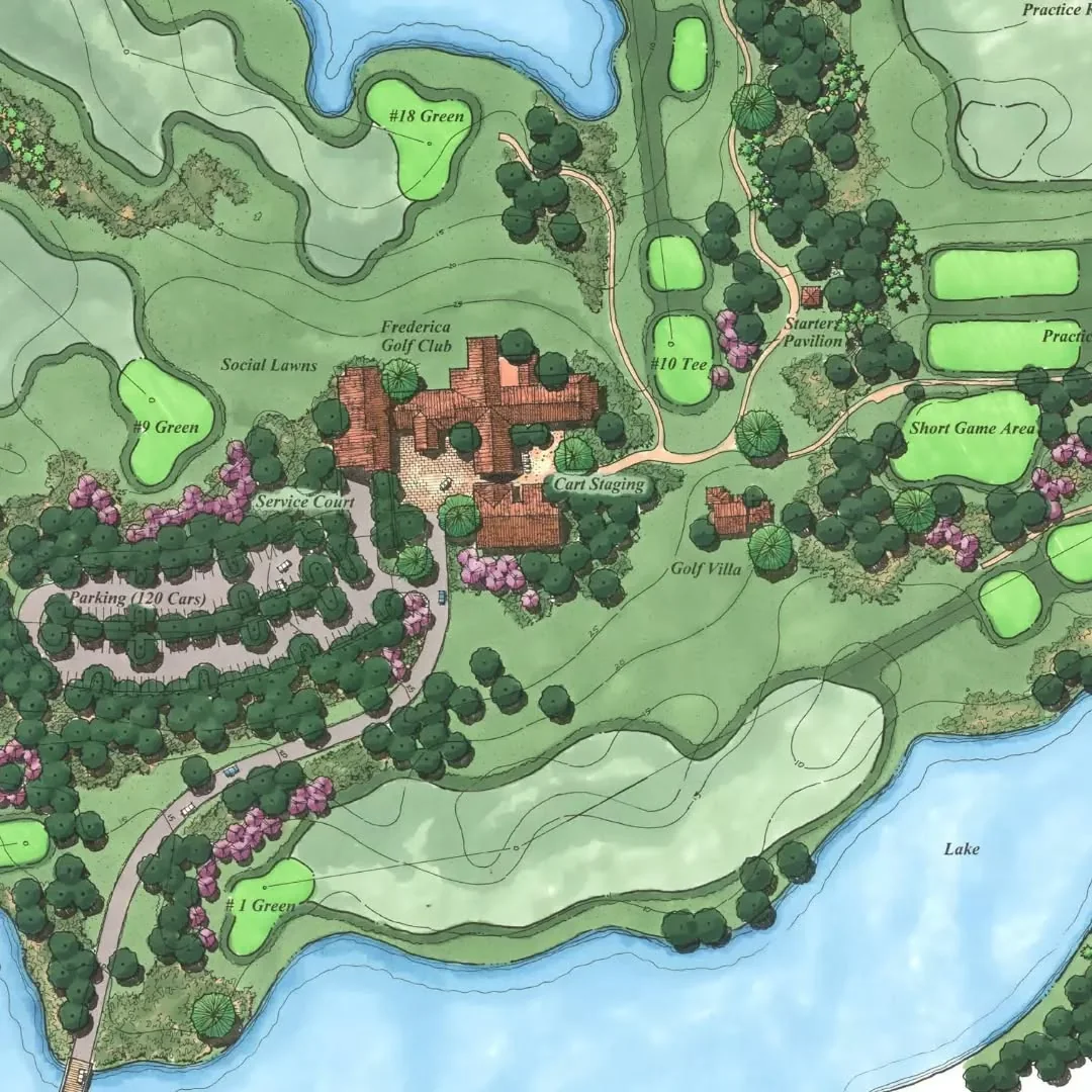
This early site plan by EcoPlan covers the clubhouse area at Frederica Golf Club, inside a residential community that the firm master planned for The Sea Island Company. Frederica describes the community as a 1,700-acre private neighbourhood with 425 acres of interconnected lakes, and the course is by Tom Fazio.
The sheet shows how a master plan for a golf community is really a plan for edges. The clubhouse sits between the 1st, 9th, 10th and 18th holes, so every main view runs across water or fairway. Parking for 120 cars is pushed into tree cover to the west, and the “Social Lawns” make the step between building and course. Hand-rendered trees and pink flowering shrubs give a reviewer an idea of mood without fixing species.
The EcoPlan project page calls Frederica an ultra-exclusive, low-density woodland community with 14 miles of trails. That is the limit of this type: the landscape is generous, but it is private and gated, so the open space in the plan serves members, not the public.
10. West Beach Seafront (2024) – Newhaven, England
Landscape architect: Turkington Martin | Client: Lewes District Council | Approved: August 2024

The red line on this plan draws a seafront park between the shingle beach and the vegetated slopes behind it. According to Turkington Martin, Lewes District Council approved the detailed application unanimously on 14 August 2024. The scheme, designed with Morgan Carn Architects, adds a destination restaurant of 378 m² according to Lewes District Council, community facilities, an outdoor gym, children’s play and a splash pad, close to a Site of Special Scientific Interest and the Scheduled Ancient Monument of Newhaven Fort.
The plan reads from east to west. The design is a series of layers running from the Old Battery in the east to retained vegetated shingle and grassland in the west, with wave-shaped paths, play areas and built features threaded through them. That gradient is a waterfront master plan decision: the busiest uses go where the ground is already disturbed, and the most fragile habitat is left at the far end.
The weakness lies outside the red line. Time Out reports that the beach itself has been closed since 2008 by its owner, Newhaven Port and Properties, which judged its waves and crumbling walls too dangerous, and that a bill to restore public access was put to Parliament in 2026. A seafront park can be approved while the sand next to it stays shut. Lisbon faces a similar question of linking a city to its river edge, covered in our report on the Marvila masterplan by MVRDV and OODA.
Honorable Mentions
Riverside General Plan (1869) – Riverside, Illinois, USA
Olmsted, Vaux and Co. planned this 1,600-acre suburb six miles west of Chicago with curving streets and a park along the Des Plaines River, and the Cultural Landscape Foundation notes it became a National Historic Landmark in 1969. It stays out of the main list only because no high-resolution public domain copy of the plan was available to show here.
Golden Gate Park (1870) – San Francisco, USA
William Hammond Hall drew the first survey and plans for this 1,017-acre park on sand dunes, and more than 155,000 trees were planted to hold the ground, according to The Cultural Landscape Foundation. The surviving map we found is a later bicycle guide, so the plan itself could not be shown.
Academical Village (1817) – Charlottesville, Virginia, USA
Thomas Jefferson’s plan for the University of Virginia set ten pavilions along a terraced Lawn with the Rotunda at its head, and it became part of a World Heritage Site in 1987. It is one of the best known campus plans in the United States, but the period engravings on Wikimedia Commons are too small to reproduce well.
Plan of Chicago (1909) – Chicago, USA
Daniel Burnham and Edward Bennett’s Plan of Chicago argued that the lakefront belongs to the people, and all but four of the city’s 29 miles of lakefront are now public parkland. It is a city plan more than a park plan, which is why Jackson Park represents the lakefront here instead.
Patterns Across the Ten Master Plans
Water fixes the structure first
The two lakes of the Bois de Boulogne, the lagoons of Jackson Park and the lake on the Buttes-Chaumont quarry all decide where the drives go, not the other way round. At West Beach the same logic runs along the shingle, with the most fragile ground left at the far end. Draw the water and the levels first, and the rest of the master plan has something to follow.
The plan that wins is rarely the plan that gets built
Bénard won at Berkeley and Howard built it, the Arkansas Group Plan stopped when the money did, the McMillan Plan was never formally adopted, and the Hersted competition was followed by six years of waiting before a new masterplan emerged. A landscape master plan is a starting position, and the people who carry it out will change it.
Land deals are drawn on the same sheet
Prospect Park’s “For sale” blocks, the reserved building sites around the McMillan Mall and Frederica’s lots around the course all show that a master plan decides who owns what as much as what goes where. Reading those labels is often the fastest way to understand why a park has its shape.
Ground conditions catch up with the drawing
Buttes-Chaumont is still paying for its gypsum, and Varé’s stream in the Bois de Boulogne failed because the levels were wrong. Jackson Park shows the political version of the same problem, where a later building claims land the plan had kept open. The sheet records an intention; the ground and the city keep voting on it.
Frequently Asked Questions
Which is the largest landscape master plan in this list?
The Bois de Boulogne, at 845 hectares, followed by the 1,700-acre Frederica community on St. Simons Island. The smallest park in the list is Buttes-Chaumont at 24.7 hectares, and the smallest site overall is the West Beach seafront in Newhaven.
Which of these master plans were not built as drawn?
Bénard’s Phoebe Hearst Plan was rewritten by John Galen Howard, the Arkansas Group Plan stopped when funding ran dry, and the McMillan Plan was carried out piecemeal. The Hersted entry by Brisac Gonzalez and MAXWAN was shortlisted, but another team won the competition.
Which is the oldest plan, and which is the newest?
The oldest sheet is the 1862 plan of the Bois de Boulogne, followed by Buttes-Chaumont in 1867. The newest is Turkington Martin’s West Beach scheme in Newhaven, approved by Lewes District Council in August 2024.
What This Means for Your Next Project
Your Next Step: Before you colour a single tree, lay a sheet of tracing paper over your site and mark only three things: water, levels and who owns each piece of land. Every plan in this list that lasted was built on those three layers, and if your master plan works with only them, the planting and the renders will have something solid to sit on. For a look at how parks support the city around them, see our article on park areas in urban design.






Landscape Architecture Section Drawings: 12 Examples and How They Are Built
Twelve real landscape sections, from Salomon Kleiner's Weißenstein garden profile and the...
illustrarch Editoral Team17 Mins read
Landscape Architecture Drawings: Plans, Sections and Diagrams Explained with Real Examples
Seven real landscape architecture drawings, one for each type: the Emerald Necklace...
illustrarch Editoral Team11 Mins read

Top Rated Landscape Architecture Schools in the US, Europe, and Beyond
From Harvard GSD and UC Berkeley to Wageningen University in Europe, the...
 Sinan Ozen10 Mins read

Top 10 Landscape Architecture Books Every Designer Should Read
A focused guide to ten landscape architecture books covering ecology, planting design,...
 Bahattin Duran6 Mins read


Leave a comment